



















According to the most recent situation report from the United Nations Office for Coordination of Humanitarian Affairs, the number of people displaced by flooding in Namibia “has increased to 54,581 (previous reports indicated up to 13,000 displaced). Serious damage to roads and bridges hampers full access to the affected population, estimated at 344,000 people.” Although the rivers of this low-lying region flood each year during the rainy season, the rain and flooding in 2009 have been exceptional.
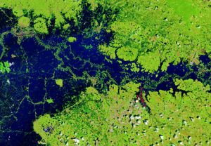
This pair of images from the Advanced Spaceborne Thermal Emission and Reflection Radiometer (ASTER) on NASA’s Terra satellite shows flooding along the Chobe River. The river’s flood plain is lake-like. The images combine visible and infrared wavelengths of light to make flood water (dark blue) stand out form vegetation (red) and naturally bare or developed land (pale tan or nearly white). On April 3, 2009, water was spilling out across the Chobe River flood plain into croplands and villages. The image from June 2007 (bottom) illustrates the size of the river in the dry season.
References & Resources
- U.N. Office for Coordination of Humanitarian Affairs. (2009, April 8). Southern Africa: Flood and Cyclone Situation Report No. 3. ReliefWeb Website. Accessed April 10, 2009.
NASA image created by Jesse Allen, using data provided courtesy of NASA/GSFC/METI/ERSDAC/JAROS, and U.S./Japan ASTER Science Team. Caption by Rebecca Lindsey.