![Request for Information – Potential [Placeholder for Prize]](https://assets.science.nasa.gov/dynamicimage/assets/science/psd/solar/2023/09/s/solarsystem_0.jpg?w=1024)


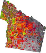
This false-color image shows the gradual conversion of forest lands for agricultural use in the Tierras Bajas region of Santa Cruz, Bolivia, as observed by the Thematic Mapper (TM) flying aboard Landsat 5.
Forest and woodland are represented as grey tones from Channel 5 in this TM scene, collected in 1998. Other colors indicate the first year in which a site was developed for agriculture (see color scale in the image, which corresponds to years of development).
In this scene, land use types are delineated with lines. Solid white lines show the locations of planned colonies, dashed white lines show spontaneous colonies, and dotted white lines show Mennonite colonies. All other regions of development are non-Mennonite industrial soybean farms.
Natural vegetation formations in this image are delineated with black lines. Solid black lines show the locations of Northern Chaco Woodlands and dashed black lines show Cerrado regions.
For more information, see this previous Image of the Day regarding Bolivian deforestation.
References & Resources
Image courtesy Marc Steininger, NASA GSFC