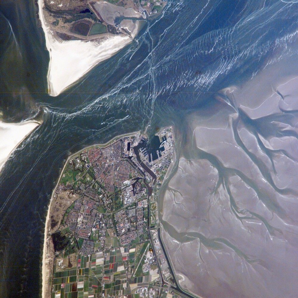

The city and harbor of Den Helder in the northern Netherlands has been the home port of the Dutch Royal Navy for over 175 years. The location provides access to the North Sea, which has made it an important commercial and strategic port. Bright red agricultural fields to the south of Den Helder indicate another noteworthy aspect of the region—commercial farming of tulips and hyacinth. This astronaut photograph is an oblique view (an angled, not a “straight down”view) of the Den Helder region taken from the International Space Station (ISS). The ISS was located to the southeast, near Dülmen, Germany, when the image was acquired, about 225 kilometers (140 miles) away in terms of ground distance.
In addition to the urban structures of the Den Helder area (reddish-gray to gray street grids) and dockyards to the east of the city, several striking natural features are visible. The prominent branching pattern of the extensive gray mudflats (image bottom right) indicate that this image was acquired at low tide, and show the generally low elevation of the region. Parallel wave patterns along the mudflats and in the Marsdiep Strait are formed as water interacts with the sea bottom between Den Helder and Texel Island during tidal flow. (Some ship wakes are also visible.) The bright, white-gray triangular region at the southern tip of Texel Island (image upper left) is a dune field, consisting mainly of eolian (wind-borne) sands deposited during the last ice age. Subsequent sea level rise and shoreline processes have shifted these sands into their current configuration, which includes a new dune field island to the southwest of Texel.
References & Resources
The featured astronaut photograph ISS015-E-5977 was acquired May 1, 2007, with a Kodak 760C digital camera using an 800 mm lens, and is provided by the ISS Crew Earth Observations experiment and the Image Science & Analysis Laboratory, Johnson Space Center. The image in this article has been cropped and enhanced to improve contrast. The International Space Station Program supports the laboratory to help astronauts take pictures of Earth that will be of the greatest value to scientists and the public, and to make those images freely available on the Internet. Additional images taken by astronauts and cosmonauts can be viewed at the NASA/JSC Gateway to Astronaut Photography of Earth.