


browse image of orbit 5969 (380 KB JPEG)
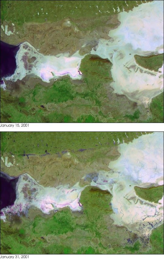
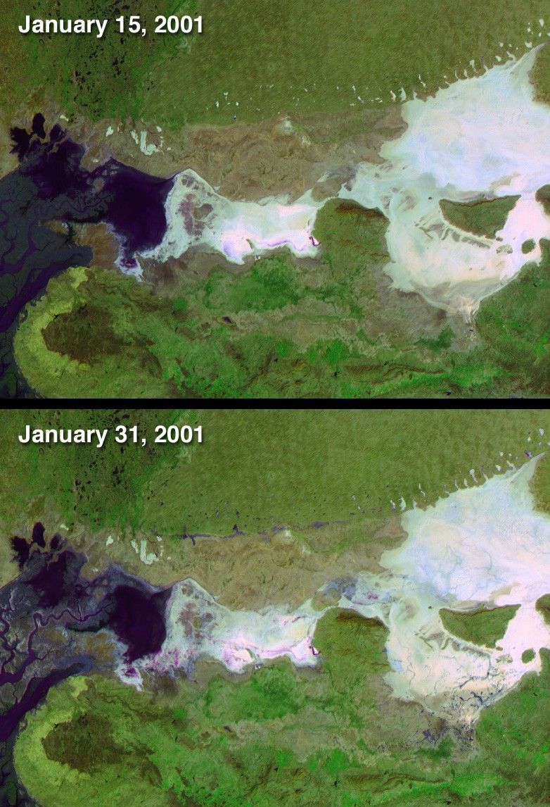
On January 26, 2001, when India’s Republic Day is normallycelebrated, a devastating earthquake hit the state of Gujarat. About20,000 people died and millions were injured throughout the region. Theearthquake had a magnitude of 7.7 on the Richter scale. After theearthquake, local residents reported a mixture of water and sedimentsfountaining from the Earth. These effects, referred to as dewatering,can result from intense ground shaking by strong earthquakes in regionswith shallow water tables. Scientists initially observed dewatering inparts of the Rann of Kutch (a large salt pan in northern Gujarat), andin areas close to the earthquake epicenter. Recent research utilizes theunique capabilities of the Multi-angle Imaging SpectroRadiometer (MISR)instrument to observe earthquake-related dewatering over a broader area(related story: NASA Satellite Helps Scientists See Effects ofEarthquakes in Remote Areas). This research is published in theFebruary 4, 2003, issue of EOS Transactions of the American GeophysicalUnion.
These two false-color MISR images were acquired before and after theevent, on January 15 and 31, respectively. The earthquake epicenter waslocated about 80 kilometers east of the city of Bhuj, situated in thelower part of the images. The later image depicts numerous areas wheregroundwater flowed up to the surface, including within the Rann ofKutch, as well as near the Indo-Pakistani border. These regions ofearthquake-associated surface water are apparent up to 200 kilometersfrom the earthquake’s epicenter. Water was observed in many remoteareas, especially near the Indo-Pakistani border, which were not easilyaccessible to survey teams on the ground.
Changes in reflection at different view angles and in thenear-infrared spectral region assist with the identification of surfacewater, which appears here in shades of blue and purple. In thesevisualizations, data from the red band of MISR’s most obliquelybackward and forward-viewing cameras are displayed as red and blue,respectively, and data from the near-infrared band of MISR’svertically-downward viewing (nadir) camera are displayed as green. Waterbodies tend to be more absorbing in the near-infrared, and to bebrighter in the view acquired by the more sun-facing (in this case, the70-degree forward) camera. This combination enhances the ability todistinguish wet surfaces. Truecolor and multi-angle visualizations of these data were also releasedin April 2001.
The Multi-angle Imaging SpectroRadiometer observes the daylit Earthcontinuously and every 9 days views the entire globe between 82 degreesnorth and 82 degrees south latitude. The MISR Browse Image Viewer provides access tolow-resolution true-color versions of these images. This data product was generatedfrom a portion of the imagery acquired during Terra orbits 5736 and5969. The full-size images cover an area of 215 kilometers x 156 kilometers, andutilize data from blocks 71 to 72 within World Reference System-2 path151.
References & Resources
Image courtesy NASA/GSFC/LaRC/JPL, MISR Team. Text by Clare Averill (Acro Service Corporation/JPL) and David J. Diner (JPL).


