


In mid- to late September 2025, drought conditions across the United States were mixed, with some areas seeing improvement while others worsened. The Northeast was one such place where conditions deteriorated amid persistently dry weather.
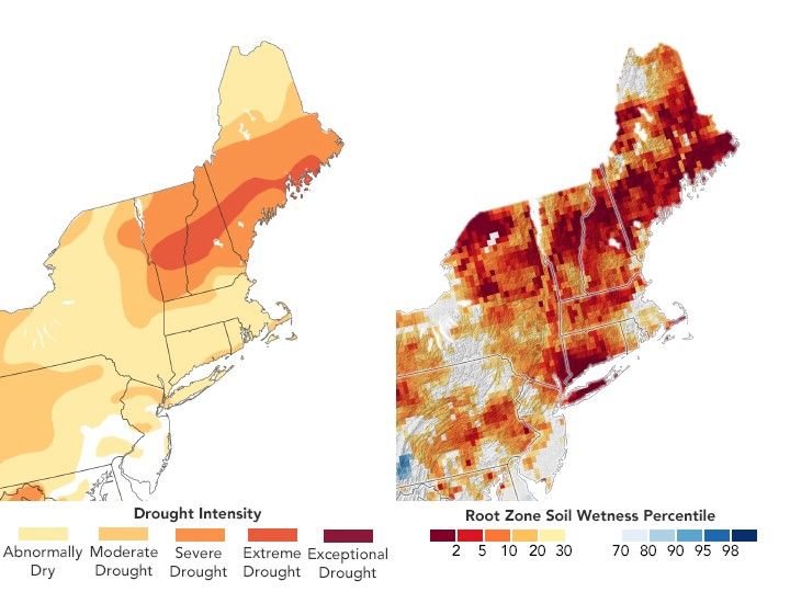
The map on the left shows drought conditions in the U.S. Northeast as of September 23, 2025. The map is a product of the U.S. Drought Monitor, a partnership of the U.S. Department of Agriculture (USDA), the National Oceanic and Atmospheric Administration, and the University of Nebraska–Lincoln. In the week leading up to this date, extreme drought (dark orange) spread across northern New England.
The prolonged dryness has impacted crops and pastureland, reduced streamflow, lowered lake levels, and caused groundwater shortages, according to a September 25 update from the Northeast Regional Climate Center. Around 24 percent of Vermont and 33 percent of New Hampshire were experiencing extreme drought, which is the largest expanse of this drought level observed in those states since the start of U.S. Drought Monitor records in 2000.
One sign of the drought appears in the upper layer of soil known as the “root zone”—the layer of soil most critical for agriculture. When this soil lacks enough water, seeds may not germinate, and plant growth can be stunted. In late September, large portions of agricultural areas in New York, Vermont, New Hampshire, Maine, and West Virginia had inadequate soil moisture for healthy plant growth.
The map on the right shows soil moisture in the root zone as of September 23, based on data from the GRACE-FO (Gravity Recovery and Climate Experiment Follow On) satellites, combined with other observations. The colors indicate soil moisture percentiles—how soil moisture compares to long-term records (1948 to 2012) for that date. Blue areas indicate wetter-than-usual soil conditions, while orange and red areas are drier than normal. The darkest red areas reflect dryness levels that typically occur only 2 percent of the time, or about once every 50 years.
According to the Northeast Regional Climate Center, the lack of water has led to feed crop losses in Vermont, undersized pumpkins in Maine and New York, and small, stressed tree farms in New Hampshire. News reports also noted that tourism has been affected in some areas, with an early influx of leaf peepers hoping to catch fall colors that arrived sooner than usual.
At the time of the U.S. Drought Monitor’s weekly report, there were signs that some relief might be on the way. A cold front was expected to bring widespread rainfall to the region, and forecasters were monitoring tropical activity in the Atlantic. However, the outlook for early October still called for below-normal rainfall and above-normal temperatures across much of the Northeast.
References & Resources
- Drought.gov (2025, September 23) National Drought Status. Accessed September 26, 2025.
- Northeast Regional Climate Center (2025, September) A Dry but Cool Start to September. Accessed September 26, 2025.
- NBC News (2025, September 20) Bright, brief and early: New England’s fall foliage may not last long. Accessed September 26, 2025.
- U.S. Drought Monitor (2025, September 25) This Week’s Drought Summary. Accessed September 26, 2025.
NASA Earth Observatory image by Lauren Dauphin, using data from the United States Drought Monitor at the University of Nebraska-Lincoln and GRACE data from the National Drought Mitigation Center . Story by Kathryn Hansen.


