


High winds, low humidity, and drought-parched grasses fueled a rash of wildfires in Texas, Oklahoma, and Arkansas in mid-March 2022. According to the Texas A&M Forest Service, at least 178 wildfires have burned more than 108,000 acres across Texas in the past seven days, including one of the largest blazes (by area) in state history. At least three first responders have died in Texas and Oklahoma while responding to the fires.
On March 20, 2022, the Moderate Resolution Imaging Spectroradiometer (MODIS) on NASA’s Aqua satellite acquired images of fires scattered across the Southern Plains of the United States. The natural-color image above is overlaid with red boxes indicating locations where MODIS detected heat signatures indicative of fire. The false-color image below combines visible and shortwave infrared light (MODIS bands 7,2,1). Active fires appear orange; burn scars are brown; unburned vegetation is green; lakes and reservoirs are navy blue; and developed areas are gray.
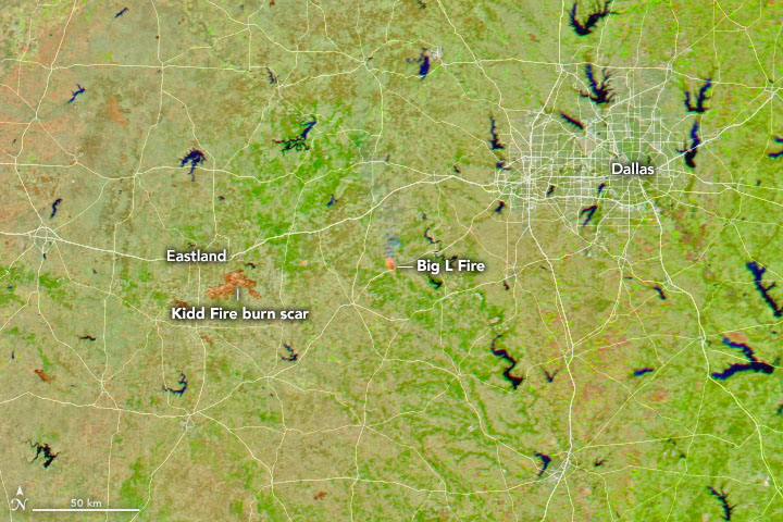
About 125 miles west of Dallas, the Kidd Fire ignited on March 17 amid days of strong, dry winds. (This short time-lapse sequence shows dust and clouds caught up in the winds.) More than 42,000 acres (65 square miles) have burned so far in a fire that is about 40 percent contained. At least 147 homes and structures have been consumed, including most of the town of Carbon. The Kidd Fire is one of seven that have been grouped into the Eastland Complex by firefighting agencies; more than 54,000 acres (84 square miles) of wildland and property have burned near the town of Eastland.
On March 20, strong winds fueled new fires in grasslands in Oklahoma, Arkansas, and Texas. The time-lapse imagery below from the GOES-East weather satellite shows smoke streaming north on strong southerly winds.
As evening approached yesterday, the #GOESEast ?? monitored the smoke from numerous wildfires that ignited across Texas and Oklahoma. The fires are being fueled by favorable weather conditions including warm temperatures, low humidity, and strong winds. pic.twitter.com/zt62zKe0Nk— NOAA Satellites (@NOAASatellites) March 21, 2022
By the morning of March 21, more than 11,000 acres had burned in the Big L Fire near Lipan, Texas; firefighters had the wildfire about 20 percent contained. Rain was forecast for Central Texas late on March 21, which could aid firefighting. At the same time, forecasters also warned of serious potential for fire in southwest Texas as a strong weather front moved in.
According to the U.S. Drought Monitor on March 17, nearly 75 percent of the South Central U.S. facing some level of drought, with 31 percent enduring extreme or exceptional conditions. Roughly 91 percent of Texas and 86 percent of Oklahoma was in drought.
In research published in November 2021, scientists found that burned acreage from wildfires in the western United States doubled between the period of 1984-2000 and 2001-2018. They attributed the increase in fire to a significant increase in the vapor pressure deficit, a measurement of how hot and dry the atmosphere can get. Global warming, they noted, is increasing vapor pressure deficits, which makes vegetation more susceptible to burning and the atmosphere more conducive to sustaining fire.
References & Resources
- Associated Press (2022, March 21) Rain finally in forecast for Texas areas scorched by fires. Accessed March 21, 2022.
- NOAA National Integrated Drought Information System (2021, November 9) Study Shows That Climate Change is the Main Drive of Increasing Fire Weather in the Western U.S. Accessed March 21, 2022.
- KFOR (2022, March 21) Texas wildfire updates: Latest on evacuations, containment, acres burned in Eastland and Hood counties. Accessed March 21, 2022.
- Reuters (2022, March 19) Texas wildfires destroy 86 homes, most of small town. Accessed March 21, 2022.
- Texas A&M Forest Service (2022, March 21) Wildfire Potential Increases Today in Southwest Texas as Firefighters Continue to Contain Several Large Wildfires from Thursdayâs Southern Plains Wildfire Outbreak. Accessed March 21, 2022.
- Texas A&M Forest Service (2022, March 19) Wildfire Update. Accessed March 21, 2022.
- Texas Wildfire Incident Response System (2022, March 21) Texas Wildfire Public Viewer. Accessed March 21, 2022.
- WFAA (2022, March 21) Texas wildfire updates: Latest on evacuations, containment, acres burned in Eastland and Hood counties. Accessed March 21, 2022.
- Wildfire Today (2022, March 20) Fire activity in Arkansas seen from airliner. Accessed March 21, 2022.
- Zhuang, Y. et al. (2021) Quantifying contributions of natural variability and anthropogenic forcings on increased fire weather risk over the western United States. Proceedings of the National Academy of Sciences, 118 (45) e2111875118.
NASA Earth Observatory images by Joshua Stevens , using MODIS data from NASA EOSDIS LANCE and GIBS/Worldview , and data from the Fire Information for Resource Management System (FIRMS). Story by Michael Carlowicz .


