![Request for Information – Potential [Placeholder for Prize]](https://assets.science.nasa.gov/dynamicimage/assets/science/psd/solar/2023/09/s/solarsystem_0.jpg?w=1024)


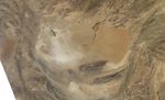
Straddling the borders of Iran, Pakistan, and Afghanistan, the Hamoun Wetlands had long been an oasis in the otherwise arid landscape of Central Asia. By the turn of the twenty-first century, however, these wetlands were desiccated by irrigation and drought. In mid-May 2008, a dust storm arose from dry lake beds left behind by the once-moist wetlands.
The Moderate Resolution Imaging Spectroradiometer (MODIS) on NASA’s Aqua satellite took this picture on May 18, 2008. The pale beige plume in the lower left portion of the image is dust rising from the Hamoun Wetlands. The dust appears especially thick over Gowd-e Zereh, an impermanent salt lake. Gowd-e Zereh is the lowest part of the Hamoun Wetlands, but it is separated from other portions of the wetlands by a land barrier. Even when the area is not plagued by drought, Gowd-e Zereh receives water only when other parts of the wetlands produce unusually abundant runoff.
References & Resources
- References
- Weier, J. (2002, December 13). From Wetland to Wasteland. NASA Earth Observatory. Accessed May 19, 2008.
- Ehlers, E. Geography of Lake Hâmun. Iran Chamber. Accessed May 19, 2008.
NASA image courtesy the MODIS Rapid Response Team at NASA GSFC. The Rapid Response Team provides daily images of this region. Caption by Michon Scott.