


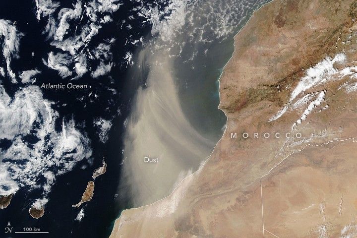
Dense bands of dust streamed offshore from southern Morocco in summer 2024. The VIIRS (Visible Infrared Imaging Radiometer Suite) on the Suomi NPP satellite acquired this image of a plume of Saharan dust as winds lofted it over the Atlantic Ocean on August 24, 2024.
The Sahara Desert is Earth’s largest source of airborne dust, and the particles can travel for thousands of miles. From late spring to early fall, it is common for the dry, dusty Saharan Air Layer to carry the particles westward across the Atlantic Ocean high in the atmosphere. With different wind patterns in the winter and spring, dust emerging from North Africa can drift over the United Kingdom and western Europe at relatively low altitudes.
Saharan Air Layer activity subsides after mid-August, according to NOAA, making it less likely that the plume shown here is bound for a transoceanic journey. Instead, it arcs to the north after blowing out over the ocean. Earlier in the summer, however, several clouds of fine dust from the Sahara reached the United States, creating hazy skies over Texas.
Scientists are interested in summertime Saharan dust events in part because of the influence they can have on large storm systems. Dry, stable, dust-laden air can inhibit tropical cyclone formation in the North Atlantic. And in a new study, researchers found that dust can modulate the amount of rainfall brought by these storms.
Using a machine-learning model based on meteorological data, NASA’s IMERG (Integrated Multi-Satellite Retrievals for GPM) precipitation estimates, and other satellite measurements, the study’s authors found that dust optical depth—a measure of how much light filters through a dusty plume—was a key predictor of rainfall from tropical cyclones. They concluded that, at lower amounts, dust particles promote the formation of rain-producing clouds, while at higher concentrations, the sunlight-blocking effects of dust serve to suppress precipitation.
References & Resources
- NASA Earth Observatory (2024, March 28) Desert Dust Envelops Portugal and Spain. Accessed August 27, 2024.
- NOAA Atlantic Oceanographic & Meteorological Laboratory The Saharan Air Layer. Accessed August 27, 2024.
- Space.com (2024, July 9) Saharan dust outbreak lingers across some US states this week. Accessed August 27, 2024.
- Zhu, L., et al. (2024) Leading role of Saharan dust on tropical cyclone rainfall in the Atlantic Basin. Science Advances, 10, eadn6106.
NASA Earth Observatory image by Lauren Dauphin, using VIIRS data from NASA EOSDIS LANCE , GIBS/Worldview , and the Suomi National Polar-orbiting Partnership . Story by Lindsey Doermann .


