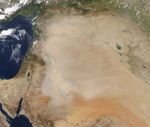



















In early May 2012, a dust storm blew over the Middle East, particularly east of Damascus. The storm covered most of Syria, and extended into Iraq, Jordan, and Saudi Arabia. The Moderate Resolution Imaging Spectroradiometer (MODIS) on NASA’s Aqua satellite captured this natural-color image on May 11. The dust was thickest in the west, especially over Jordan and northern Saudi Arabia, and thinning toward the east.
Source points for this storm aren’t obvious in this image, but the vast sand seas of the Arabian Peninsula provide plentiful material for dust plumes. In addition, impermanent rivers and salt lakes occur throughout the region. The fine sediments from these features, as well as from the Tigris and Euphrates floodplains, can feed dust storms.
In a study published in 2012, scientists analyzed the particulate matter found in dust storms over Iraq from December 2008 to March 2009 and found that the particles were (from most to least abundant) silt, clay, and sand. As clay and silt particles are much smaller than sand grains, they can be lofted into the air by lighter winds and may occur more frequently in dust storms.
References & Resources
- Al-Dabbas, M.A., Abbas, M.A. (2012) Dust storms loads analyses—Iraq. Arabian Journal of Geosciences, 5(1),121–131.
- University Corporation for Atmospheric Research. Forecasting Dust Storms. (Registration required).
NASA image courtesy LANCE MODIS Rapid Response. Caption by Michon Scott.