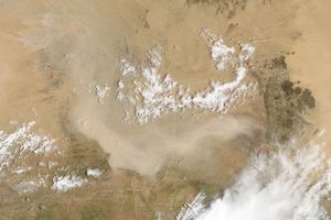





























Dust blew across the Taklimakan Desert at the end of February 2011. The Moderate Resolution Imaging Spectroradiometer (MODIS) on NASA’s Aqua satellite captured this natural-color image on February 28, 2011.
The Taklimakan Desert sits in the Tarim Basin, between the Tien Shan (or Tian Shan) mountain range in the north and the Kunlun Shan range to the south. Mobile sand dunes, some reaching a height of 200 meters (650 feet), fill 85 percent of the Taklimakan, which ranks among the world’s largest shifting-sand deserts.
Dust is thick enough to completely hide the desert floor along the southern rim of the Tarim Basin in this image. Along the western margin, ripples appear on the surface of the dust plume. A thin but discernible haze dulls the snowy white of the mountains to the north.
References & Resources
- World Wildlife Fund and Mark McGinley (2007). Taklimakan Desert. Encyclopedia of Earth. Accessed February 28, 2011.
NASA image courtesy Jeff Schmaltz, MODIS Rapid Response Team, Goddard Space Flight Center. Caption by Michon Scott.