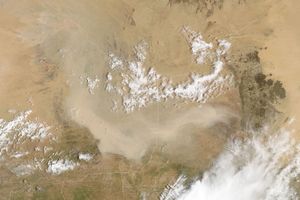

Dust filled the sky over China’s Taklimakan Desert on April 29, 2011. The Moderate Resolution Imaging Spectroradiometer (MODIS) on NASA’s Aqua satellite took this picture the same day.
The Taklimakan Desert sits in the Tarim Basin, between the mountain ranges of the Tien Shan (or Tian Shan) in the north, and the Kunlun Shan in the south. In this image, a wall of dust runs roughly parallel to the southwestern margin of the Tarim Basin. In the western half, the dust is thick enough to completely hide the desert floor. It appears slightly thinner in the east.
The Taklimakan is China’s largest and hottest desert. Isolated from the Asian monsoon and Arctic storms, the desert is deprived of moisture, and largely devoid of vegetation. Sand dunes cover about 85 percent of the desert floor.
References & Resources
- World Wildlife Fund, McGinley, M. (2007). Taklimakan Desert. Encyclopedia of Earth. Accessed May 2, 2011.
NASA image courtesy Jeff Schmaltz, MODIS Rapid Response Team, Goddard Space Flight Center. Caption by Michon Scott.