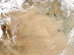

A dust storm swept through parts of Iraq and Syria on February 9, 2006. The Moderate Resolution Imaging Spectroradiometer (MODIS) flying onboard the Aqua satellite took this picture the same day.
In this image, the source points of the dust storm can be seen in the west, extending from Saudi Arabia northward into Syria. As the dust blows eastward, it dissipates into an amorphous cloud, partially but not completely obscuring the land features below. Clouds fringe the scene to the northwest, northeast, and southeast. Although they can cover large areas, dust storms often originate from discrete points. The Middle East, thanks to its deserts and extreme temperatures, provides a steady supply of dust storms.
References & Resources
NASA image courtesy Jeff Schmaltz, MODIS Land Rapid Response Team at NASA GSFC