


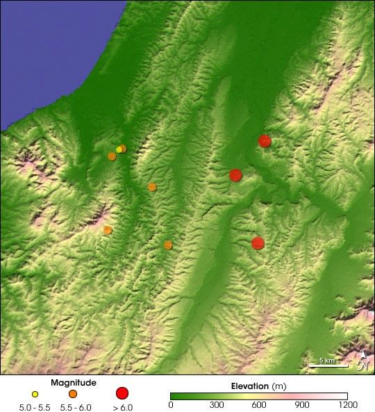
A series of powerful earthquakes over the weekend shook Niiagata Prefecture on Northwest Honshu, 260 km (160 miles) north of Tokyo. The first quake registered 6.5 on the Richter Scale, according to the National Earthquake Information Center, and occurred at 8:56 Universal Time, in the early evening local time as many residents were starting their dinners. At present, some 24 deaths have been attributed to the quake, or to the series of strong aftershocks, some above 6.0 in magnitude. Rescuers are still looking for missing people and, unfortunately, the death toll may climb further.
The quakes also injured approximately 2,000 people, stretching local hospitals to their limits. Electrical power has been cut off for some 300,000 residents. Many people remain in emergency shelters, fearful of returning to homes that may be unstable from the damage caused by the quakes.
Earthquakes are not uncommon in Japan, which rests on the Pacific “Rim of Fire,” where the Pacific plate (on which northern Honshu rests) subducts under the Eurasian Plate.
This visualization shows the topography of northwestern Japan around the initial epicenter. Color represents elevation and shading shows slope (illuminated from the lower left, as the area would appear at this time of year in the early morning). The land surface elevation data shown here were collected by NASA’s Shutte Radar Topograph Mission (SRTM) in February 2000. The locations and information about the quakes were obtained from the USGS National Earthquake Information Center.
References & Resources
NASA image created by Jesse Allen, Earth Observatory, using data obtained from the Global Land Cover Facility


