


On the afternoon of January 11, 2025, NASA’s AVIRIS-3 (Airborne Visible/Infrared Imaging Spectrometer-3) flew aboard a B200 aircraft over Los Angeles County, where it captured images of several areas affected by wildland fires.
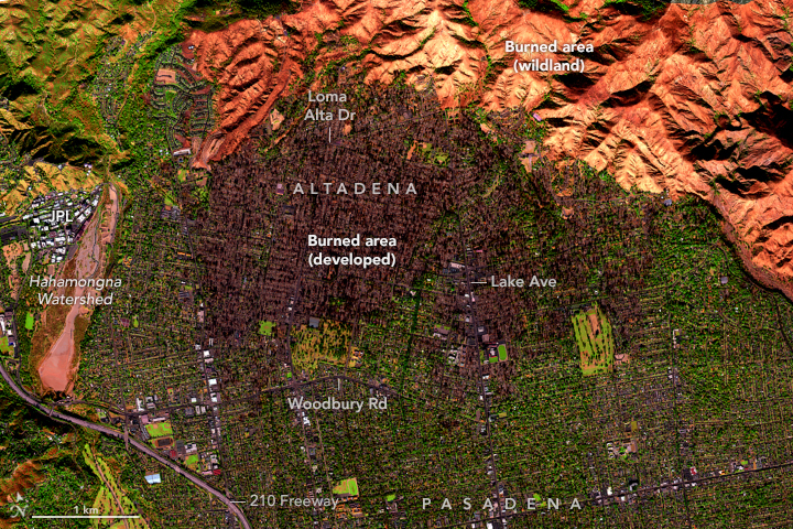
These false-color images show areas burned by the Eaton fire in Altadena and parts of Pasadena, Arcadia, and Sierra Madre. Charred trees and buildings in developed areas appear dark brown, whereas the burned wildland areas, particularly in Angeles National Forest, are shades of orange.
The Eaton fire ignited in the hills of Eaton Canyon, near Altadena, on the evening of January 7. By 10:30 a.m. the next day, the fire had quickly grown to cover more than 10,000 acres (40 square kilometers), according to Cal Fire. Around the time of this image on January 11, it had expanded to 14,117 acres (57 square kilometers), and the Los Angeles County Fire Department reported it was about 15 percent contained.
The AVIRIS-3 optical sensor collects data in 286 bands in the electromagnetic spectrum, ranging from visible violet light at a wavelength of 380 nanometers to shortwave infrared at 2,500 nanometers. In the past, AVIRIS images have been useful for investigating fire behavior and the effects of fire emissions. They are also used for post-fire analyses, such as fire severity, area burned, soil erosion, and other environmental change.
“In addition to assisting with damage assessments, these data may help us understand the chemical composition and toxic nature of ash in the post-fire environment and how it redistributes over time via wind and water flows, with subsequent data acquisitions,” said Michael Falkowski, manager of NASA’s wildland fire program.
As of the morning of January 15, the Eaton fire had stopped expanding, and it was 45 percent contained. Preliminary estimates indicate that thousands of structures were destroyed, according to Cal Fire.
NASA’s Disasters Response Coordination System has been activated to support agencies responding to the fires, including the California Governor’s Office of Emergency Services. Response activities are centered on two primary requests from the local emergency managers: damage assessment information on built infrastructure, and impacts of air quality and human health risks. The team will be posting maps and data products on its open-access mapping portal as new information becomes available.
Explore interactive maps of these images on the AVIRIS data portal.
References & Resources
- Cal Fire Eaton Fire. Accessed January 14, 2025.
- NASA Earth Observatory (2025, January 14) Smoke Streams from Palisades and Eaton Fires. Accessed January 14, 2025.
- NASA Earth Observatory (2025, January 9) Fires Tear Through Los Angeles. Accessed January 14, 2025.
- NASA Earth Observatory (2017, December 7) Earth Matters: Why the SoCal Fires are So Fierce. Accessed January 14, 2025.
- NASA JPL (2025, January 11) AVIRIS Data Portal. Accessed January 14, 2025.
- NASA JPL (2017, December 8) NASA’s AVIRIS Instrument Sheds New Light on Southern California Wildfires. Accessed January 14, 2025.
NASA Earth Observatory images annotated by Lauren Dauphin using data from Airborne Visible / Infrared Imaging Spectrometer-3 ( AVIRIS -3) instrument, via NASA Earthdata Search . The AVIRIS-3 LA Fire datasets were archived to Earthdata Search through the ORNL DAAC’s AVIRIS Facility Instrument collections. Story by Emily Cassidy .


