


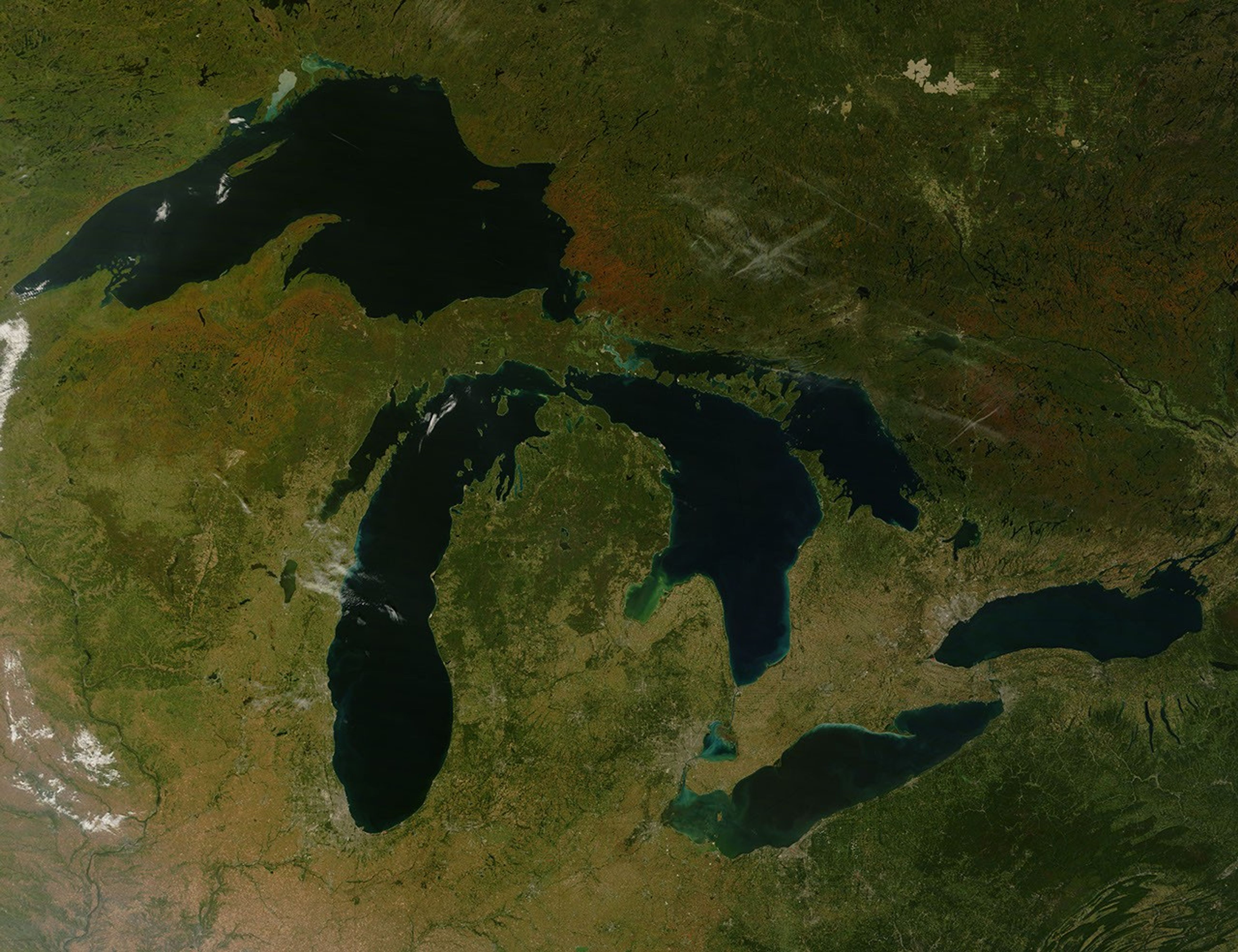
The calendar may have set September 23 as the first day of autumn in 2007, but the forests that line the eastern shore of Lake Superior had already started to mark the turning of the season. By September 23, when the Moderate Resolution Imaging Spectroradiometer (MODIS) on NASA’s Terra satellite captured this photo-like image, the forests of northern Michigan and southern Ontario flamed orange as the first trees of the season—maples—began to display their brilliant red and orange fall colors. Veins of green run through the sea of orange where the deciduous forest gives way to deep green pine trees.
The most vivid color is concentrated in Canada’s province of Ontario. Located farther south, Michigan’s trees show only a hint of color. The St. Mary’s River seems to be the dividing line between the brightest colors and the as-yet-unchanged forest. The river is also the border between the United States and Canada, as well as the only waterway linking Lake Superior to the rest of the Great Lakes. Orange and green forest gives way to gray along the banks of the river where the cities of Sault St. Marie, Ontario, and Sault St. Marie, Michigan, are located. Separated into two cities by the split between Canada and the United States after the Revolutionary War, the city was the first permanent European settlement in either Ontario or Michigan. A faint tan line spanning the river is the bridge that links the two cities. The pale green grid south of Sault St. Marie, Michigan, reveals patterns of land use, either from agriculture or forestry.
The large image provides an unusually cloud-free view of all of the Great Lakes. Similar spots of color stretch across southern Canada and parts of Michigan, Wisconsin, and Minnesota. The northern plains of the United States have started to turn yellow as grasses ripen, but the eastern forests in Pennsylvania and New York remain deep green. Red squares scattered throughout the large image mark the locations of fires. The large image is at MODIS’ maximum resolution of 250 meters per pixel. The image is available in additional resolutions from the MODIS Rapid Response System.
- Fall Color Report 2007, Accessed September 25, 2007.
- Sault St. Marie Visitor’s Bureau Accessed September 25, 2007.
References & Resources
NASA image courtesy Jeff Schmaltz, MODIS Rapid Response Team at NASA GSFC.


