October 17, 2013, will go down as one of the worst fire days New South Wales has seen in recent years. By 6:30 p.m. local time, 90 wildfires burned, 36 of them out of control and threatening communities near Sydney, Australia. Dry vegetation, high temperatures (above 34° Celsius or 93° Fahrenheit), and erratic winds gusting to 90 kilometers (56 miles) per hour combined to create extremely dangerous fire conditions.
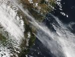
The Moderate Resolution Imaging Spectroradiometer (MODIS) on NASA’s Aqua satellite acquired this image at 2:50 p.m. (3:50 Universal Time) on October 17. Fires are outlined in red; to the east, smoke pollution was a problem in populated coastal communities. The densest plume hangs directly over Sydney, though the brighter white streak is probably a cloud.
The largest fire shown here is the State Mine fire, burning in the Blue Mountains near the Lithgow area. The fire has burned more than 20,000 hectares and damaged an unknown number of properties, according to the New South Wales Rural Fire Service. To the southeast is the dangerous Linksview Road fire, burning near the community of Springwood.
Thousands of people have been evacuated because of the fires, and all affected communities have received emergency warnings. Between the State Mine and Linksview Road fires, hundreds of homes may have been destroyed, ABC News reported.
The third large fire in the image is the Hall Road fire. Despite its size, the blaze has caused little damage and is nearly under control. It may be a few days before the other fires are under control. Weather conditions are expected to improve, but the fire danger will remain high.
References & Resources
- Australian Broadcasting Corporation News (2013, October 17) Dozens of homes lost as bushfires ravage parts of New South Wales. Accessed October 17, 2013.
- The Australian (2013, October 17) ‘Miracle’ if lives not list in NSW fires: premier. Accessed October 17, 2013.
- New South Wales Rural Fire Service (2013, October 17) Current fires and incidents. Accessed October 17, 2013.
- New South Wales Rural Fire Service (2013, October 18) Major Fire Updates. Accessed October 17, 2013 (US EDT).
NASA image courtesy Jeff Schmaltz, LANCE/EOSDIS MODIS Rapid Response Team at NASA GSFC. Caption by Holli Riebeek.