![Request for Information – Potential [Placeholder for Prize]](https://assets.science.nasa.gov/dynamicimage/assets/science/psd/solar/2023/09/s/solarsystem_0.jpg?w=1024)


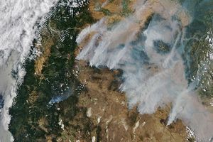
Across southeastern Australia, numerous fires were burning when the Aqua satellite passed over head on April 7, 2004. The Moderate Resolution Imaging Spectroradiometer (MODIS) sensor on the satellite collected this image and detected the locations of the actively burning fires, which are marked in yellow in this image. Fires are scattered across (clockwise from top left) South Australia, New South Wales, Victoria, and Tasmania (bottom right corner). In New South Wales and most of Victoria, the fires are located away from dense vegetation, which appears deep greenish-brown. This pattern, as well as the season, suggests they are agriculturally related fires, perhaps pasture burning. Though not necessarily immediately hazardous, such large-scale burning can have a strong impact on weather, climate, human health, and natural resources. The smokier fires on Tasmania and in eastern Victoria may be of a different nature—possibly wildfires or prescribed fires in forest lands.
The high-resolution image provided above is 500 meters per pixel. The MODIS Rapid Response System provides this image at additional resolutions.
References & Resources
Image courtesy Jeff Schmaltz, MODIS Rapid Response Team, NASA-GSFC