


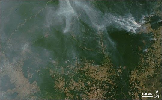
Roads and clearings penetrate the southeastern margin of the Amazon. Along with these human incursions come fires—some intentional and some accidental. Between slash and burn agriculture, pasture management, and accidental fires, burning is transforming the Amazon. This image from the Moderate Resolution Imaging Spectroradiometer (MODIS) on NASA’s Terra satellite was captured on August 1, 2005. Thick smoke from scores of fires spread over the top of the image, where a large stretch of the deep-green Amazon rainforest is still mostly intact. Along the right and bottom edges, the extent of deforestation is shown in the tan and light green patches. Active fire detections are marked in red. The high-resolution image provided above is 250 meters per pixel. The MODIS Rapid Response System provides this image at additional resolutions.
References & Resources
NASA image courtesy Jeff Schmaltz, MODIS Rapid Response Team, GSFC


