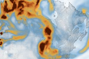

















Fires burning in West Africa during are producing high concentrations of carbon monoxide (CO) which is being measured by the Measurements ofPollution in The Troposphere (MOPITT) instrument on NASA’s Terra satellite. This false-color image shows the mixing ratio of CO at analtitude of roughly 3 km (700 hPa) averaged over March 13-18, 2003. The location of the highest mixing ratios correlates well with the location of the West African fires detected by MODIS on the Aqua satellite.
Carbon monoxide is produced by combustion processes and has a lifetime in the atmosphere of several weeks. It is a good indicator ofthe influence of pollution on downwind regions. This image shows CO being carried to the west over the tropical Atlantic Ocean.
References & Resources
Image courtesy NCAR and University of Toronto MOPITT Teams