












Suggested Searches

1 min read

Fjords of Norway


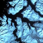
Like dark fingers, cold ocean waters reach deeply into the mountainous coastline ofnorthern Norway, defining the fjords for which the country is famous. Flanked bysnow capped peaks, some of these ice-sculpted fjords are hundreds of meters deep.

This scene was acquired by the ASTER instrument on NASA’s Terra satellite onApril 17, 2002.

References & Resources

Image provided by the USGS EROS Data Center Satellite Systems Branch as part of the Earth as Art II image series
You may also be interested in:

Stay up-to-date with the latest content from NASA as we explore the universe and discover more about our home planet.

Pasterze Hangs on as Austria’s Largest Glacier
4 min read

One narrowing icefall remains the linchpin for the Alpine glacier—and it may not be long for this world.

Article
A Changing World for Emperor Penguins
7 min read

Experts are analyzing decades of images from Landsat satellites for clues about how the iconic birds have responded to sea…

Article
June 2026 Satellite Puzzler
2 min read

Your challenge is to tell us the location of the satellite image and why it is interesting.

Article