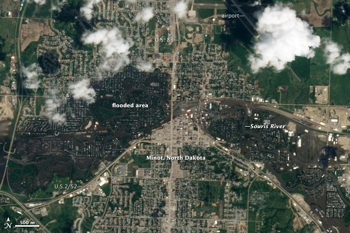
In late June 2011, the Souris River reached a record crest in Minot, North Dakota. According to the Advanced Hydrologic Prediction Service, the Souris River crested at 1,561.72 feet (476.01 meters) above sea level overnight on June 25–26. The previous record was 1,558 feet (475 meters), set in 1881.
The overflowing Souris inundated large parts of the city of Minot. The Advanced Land Imager (ALI) on NASA’s Earth Observing-1 (EO-1) satellite captured this natural-color image of the area on June 25, 2011, just as the river was reaching its historic crest.
The flooded area forms a dark arc across the center of this image, southwest to north to southeast. This arc corresponds to a map of inundated evacuation zones (PDF file) released by the City of Minot in late June 2011.
Normally the Souris River is a thin water body meandering through Minot, but the river pushed well over its banks inside and outside the city, as the high-resolution version of this image shows.
Flooding was hardly isolated to Minot. The Souris River starts and ends in Canada, looping through North Dakota on its path. A wider-area view from the Moderate Resolution Imaging Spectroradiometer (MODIS) on the Terra satellite, also acquired on June 25, 2011, shows the Souris River clearly visible throughout its southern loop. Under more typical circumstances, the Souris River largely disappears from MODIS’ view of Minot and other towns along the river.
References & Resources
- City of Minot, North Dakota. (2011). Accessed June 29, 2011.
- National Weather Service. Advanced Hydrologic Prediction Service. Accessed June 29, 2011.
NASA Earth Observatory image created by Robert Simmon, using EO-1 ALI data provided courtesy of the NASA EO-1 team. Caption by Michon Scott.