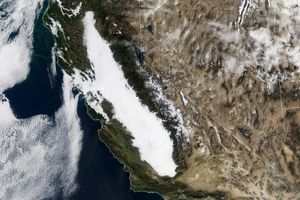
This illustration features images of southern California andsouthwestern Nevada acquired on January 3, 2001, andincludes data from three of the Multi-angle Imaging Spectroradiometer’s(MISR’s) nine cameras. The San Joaquin Valley,which comprises the southern extent of California’s Central Valley,covers much of the viewed area. Also visible are several of the ChannelIslands near the bottom, and Mono and Walker Lakes, which stand out asdarker patches near the top center, especially in the vertical andbackward oblique images. Near the lower right of each image is the LosAngeles Basin, with the distinctive chevron shape of the Mojave Desertto its north.
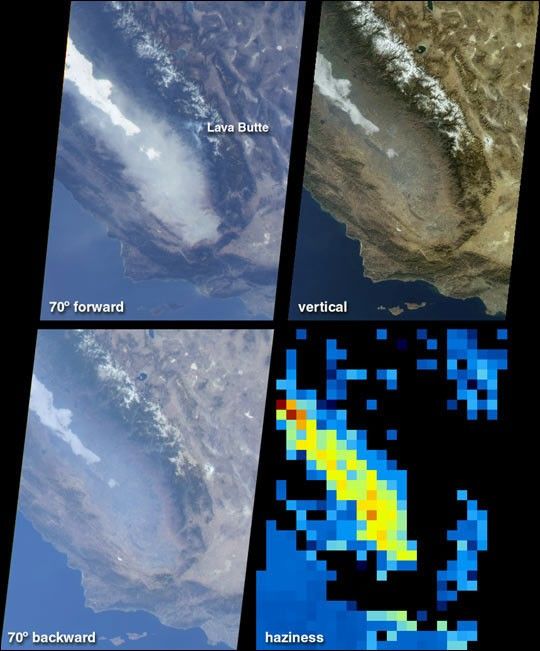
The Central Valley is a well-irrigated and richly productiveagricultural area situated between the Coast Range and the snow-cappedSierra Nevadas. During the winter, the region is noted for its hazyovercasts and a low, thick ground fog known as the Tule. Owing to theeffects of the atmosphere on reflected sunlight, dramatic differences inthe MISR images are apparent as the angle of view changes. An area ofthick, white fog in the San Joaquin Valley is visible in all three ofthe images. However, the pervasive haze that fills most of the valley isonly slightly visible in the vertical view. At the oblique angles, thehaze is highly distinguishable against the land surface background,particularly in the forward-viewing direction. Just above image center,the forward view also reveals bluish-tinged plumes near Lava Butte inSequoia National Forest, where the National Interagency CoordinationCenter reported an active forest fire.
The changing surface visibility in the multi-angle data allows us toderive the amount of atmospheric haze. In the lower right quadrant is amap of haze amount determined from automated processing of the MISRimagery. Low amounts of haze are shown in blue, and a variation in huethrough shades of green, yellow, and red indicates progressively largeramounts of airborne particulates. Due to the topographically complexterrain, no results are obtained over the Sierra Nevada and Coastalmountains and these areas are shown in black. However, the enhancedhaziness of the San Joaquin Valley is evident in this derived product.Within the yellow pixels, the Sun would look about 40% dimmer to anobserver on the ground in comparison to its brightness on a much clearerday.
References & Resources
Image courtesy NASA/GSFC/JPL, MISR Team