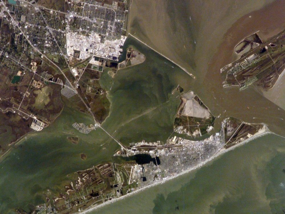
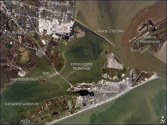
Galveston Island has alternately been a home to Native Americans, a base for Mexico’s rebellion against Spain, a pirate kingdom, a sea port, and even the capital of the Republic of Texas. In September 1900, the city was largely destroyed by a powerful hurricane. This storm damage, combined with construction of the Houston Ship Channel and discovery of oil in eastern Texas, shifted the center of trade northwest to Houston.
This astronaut photograph shows some of the human impacts in Galveston that are easily observed from the vantage point of low-Earth orbit. The city of Galveston dominates the eastern half of Galveston Island, appearing as the gray-white region at center right. A large seawall along the Gulf of Mexico—shown here along the southern coastline of Galveston Island—protects most of the city. To the west of Galveston, coastal wetlands are largely submerged by regional subsidence—sinking of the land as a result of ground water withdrawal by the petrochemical industry of Houston and Texas City.
Near the right edge of this photograph, between Galveston Island and the Bolivar Peninsula, is the entrance to Galveston Bay and the Houston Ship Channel, where ship wakes can be seen from space. Other visible features of the entrance to Galveston Bay include the five-mile-long Texas City Dike, a structure that protects the Texas City Channel and includes a fishing pier extending roughly 180 meters (600 feet) beyond the end of the dike. Extensive petroleum processing facilities are located to the west of the dike in Texas City, and the building roofs and storage tanks appear bright white in this image. The Intracoastal Waterway runs through western Galveston Bay; new subdivisions built on dredge spoils (sediment dredged during canal-building and other projects) are visible along the northern boundary of the Waterway.
Besides land uses and ship wakes, this image shows complex sediment patterns iin estuaries. Dark brown to tan waters next to the Bolivar Peninsula and Texas City Dike reflect increased sediment loads following heavy rains in mid- to late October, coupled with northerly winds moving Bay water southwards. Turbidity currents to both the northwest and southeast of Galveston Island produce a more chaotic pattern of sediment-laden (light green to tan) and relatively sediment-free (dark green) water leading into the dark green Gulf of Mexico (image lower right).
References & Resources
Astronaut photograph ISS014-E-7258 was acquired November 4, 2006, with a Kodak 760C digital camera using a 180 mm lens, and is provided by the ISS Crew Earth Observations experiment and the Image Science & Analysis Group, Johnson Space Center. The image in this article has been cropped and enhanced to improve contrast. The International Space Station Program supports the laboratory to help astronauts take pictures of Earth that will be of the greatest value to scientists and the public, and to make those images freely available on the Internet. Additional images taken by astronauts and cosmonauts can be viewed at the NASA/JSC Gateway to Astronaut Photography of Earth.