Suggested Searches

1 min read

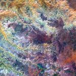
Ghadamis River in Libya


This scar on an arid landscape is the dry riverbed of the Ghadamis River in theTinrhert Hamada Mountains near Ghadamis, Libya.

This image was acquired byLandsat 7’s Enhanced Thematic Mapper plus(ETM+) sensor on November 6, 2000. This is a false-color composite image made using near-infrared, green, and blue wavelengths. The image has also been sharpened using the sensor’s panchromatic band.

References & Resources

Image provided by the USGS EROS Data Center Satellite Systems Branch
You may also be interested in:

Stay up-to-date with the latest content from NASA as we explore the universe and discover more about our home planet.

An Early Look at Fall Color in Canada
3 min read

Reds, yellows, and oranges are already sweeping across tundra landscapes in Nunavut.

Article
Rains Swamp the Gandak River
3 min read

After days of torrential rain, the river rose to record-breaking levels in parts of Nepal and India.

Article
The Beaver Brown Waters of Rupert Bay 
4 min read

Dissolved organic matter and suspended sediment mingle in the southernmost extent of James Bay.

Article