


An astronaut aboard the International Space Station (ISS) took this photograph of numerous gold prospecting pits in eastern Peru. The pits—usually hidden from an astronaut’s view by cloud cover or outside the Sun’s glint point—stand out brilliantly in this image due to the reflected sunlight. The multiple meandering channels of the Inambari River are visible on the left side of the image. The river and the pits cut through the otherwise unbroken Amazon rainforest in Peru’s Madre de Dios state.
In this very wet climate, the prospecting pits appear as hundreds of tightly packed water-filled basins. Likely dug by garimperos (independent miners), each pit is surrounded by de-vegetated areas of muddy spoil. These deforested tracts follow the courses of ancient rivers that deposited sediments, including gold. For scale, the western tract at image center is 15 kilometers (10 miles) long.
Peru is the sixth largest producer of gold in the world, and Madre de Dios is home to one of the largest independent gold mining industries in the world. Mining is the main cause of deforestation in the region, and it also can cause mercury pollution from the gold-extraction process. Yet tens of thousands of people earn their living from this unregistered mining.
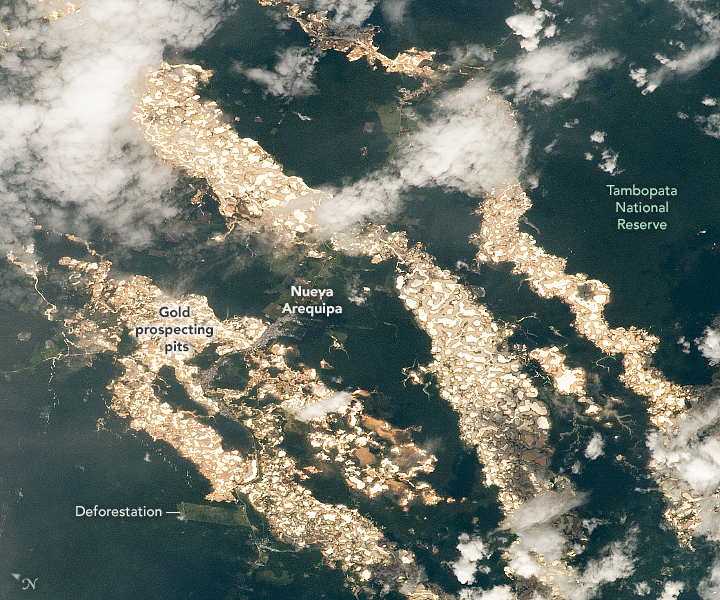
The small town of Nueva Arequipa is just visible along the Southern Interoceanic Highway. Inaugurated in 2011, the highway is the only road connection between Brazil and Peru. It was intended to stimulate trade and tourism, but due to the great expansion of surface prospecting, deforestation may be the larger result of the highway. Some areas in the state are protected from mining, such as the Tambopata National Reserve.
References & Resources
Astronaut photograph ISS064-E-16203 was acquired on December 24, 2020, with a Nikon D5 digital camera using a 400 millimeter lens and is provided by the ISS Crew Earth Observations Facility and the Earth Science and Remote Sensing Unit, Johnson Space Center. The image was taken by a member of the Expedition 64 crew. The image has been cropped and enhanced to improve contrast, and lens artifacts have been removed. The International Space Station Program supports the laboratory as part of the ISS National Lab to help astronauts take pictures of Earth that will be of the greatest value to scientists and the public, and to make those images freely available on the Internet. Additional images taken by astronauts and cosmonauts can be viewed at the NASA/JSC Gateway to Astronaut Photography of Earth. Caption by Justin Wilkinson, Texas State University, JETS Contract at NASA-JSC.


