


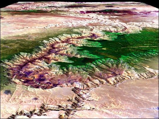
The Grand Canyon of the Colorado River cuts through the salmon-colored rock of northern Arizona’s Colorado Plateau in this westward-looking image made from a combination of observations collected by the Landsat satellite and topographic information collectedfrom National Elevation Dataset (NED). The Little Colorado is flowing in from the east (bottom) across the Painted Desert to join the Colorado River as the big river cuts into the Kaibab Plateau, to the north, and the Coconino Plateau, to the south, both of which are covered in a layer of green vegetation. The multi-colored rock formations that reveal the millions of years of geologic history of the Canyon have been displayed in shades of pink and purple in the image.
References & Resources
Landsat data provided courtesy of the Landsat Project Office, and mosaiced by Ron Hayes. Elevation data obtained from the National Elevation Dataset (NED), a seamless raster product derived primarily from the USGS 30-m Digital Elevation Models (DEMs), along with higher resolution data where available. Visualization by Jesse Allen.


