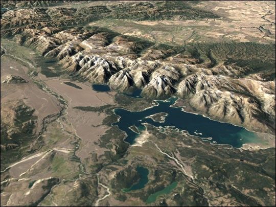
Grand Teton rises to 13,770 feet (about 4,200 meters), and twelve of the Teton peaks in the range rise above 12,000 feet (3,660 m), morethan a mile above the valley below (known as Jackson Hole). They formthe youngest section of the Rocky Mountains, yet conversely their uplifting exposes some of theoldest rock formations in North America. The gradual slope on the western side of thepeaks reflects the uplifting and tilting of the section of the North American crust shown here. TheSnake River originates here, draining into and out of Jackson Lake. Tributaries on thewestern side of the range also drain into the Snake River where Henry’s Fork merges with the mainriver south and west of the park near Idaho Falls. The Snake River forms the headwaters for theColumbia River, the largest river in the Pacific Northwest.
The Teton Range was set aside as a National Park in1929 after decades of contention with local ranchers and other land interests, and at that time onlyincluded the Teton Range and glacial lakes at their base. The area around Jackson Lake, includingnational forest and other federal lands, were declared as a national monument in 1943. The twowere merged, and a 35,000-acre section added by donation by John D. Rockerfeller, Jr., to formthe current Grand Teton National Park in 1950.
This visualization combines simulated natural color imagery from the Landsat 7 Enhanced ThematicMapper Plus (ETM+) instrument with elevation data derived from the ShuttleRadar Topography Mission (SRTM) and the United States Geological Survey’s Digital TerrainElevation Data (DTED). The elevation extrusion shown here is to proper scale with no verticalexaggeration. The view shownsimulates the view of the park and its immediate surroundings from an elevated camera lookingat the park to the south and west. These ETM+ data were acquired on September 23, 2002.
References & Resources
Data provided by the Landsat 7 Team at NASA’s Goddard Space Flight Center