


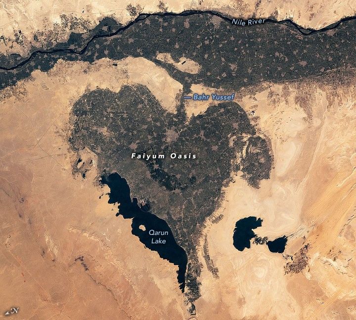
While in orbit over Egypt, an astronaut on the International Space Station (ISS) captured a photograph of this heart-shaped basin bordering the Nile River and the Western Desert. The depression, known as the Faiyum Oasis, spreads across more than 1,200 square kilometers (450 square miles) and was formed from the ancient lakebed of Lake Moeris.
Partial damming of Lake Moeris during the reign of Ptolemy II allowed large areas of fertile alluvial soil to be reclaimed for agriculture. Today saltwater Lake Qarun (Birket Qarun), located on the northern margin of the depression, is the remnant of Moeris. The salinity of Lake Qarun is caused by high evaporation rates in the arid climate.
Farms and orchards fill the depression and line the western banks of the Nile. The numerous small gray patches are villages and towns in the intensively cultivated agricultural areas. The area has supported human life for more than 8,000 years and provides resources to many bird and fish species, as well as the endangered slender horned gazelle.
Bahr Yussef, which connects the Nile to the Faiyum Oasis, originally formed as a natural offshoot of the river. In 2300 BC, it was widened and deepened into a canal to help regulate flow to the oasis. The canal transports freshwater and sediment to the area before emptying into Lake Qarun.
References & Resources
Astronaut photograph ISS065-E-66742 was acquired on May 25, 2021, with a Nikon D5 digital camera using a focal length of 100 millimeters. It is provided by the ISS Crew Earth Observations Facility and the Earth Science and Remote Sensing Unit, Johnson Space Center. The image was taken by a member of the Expedition 65 crew. The image has been cropped and enhanced to improve contrast, and lens artifacts have been removed. The International Space Station Program supports the laboratory as part of the ISS National Lab to help astronauts take pictures of Earth that will be of the greatest value to scientists and the public, and to make those images freely available on the Internet. Additional images taken by astronauts and cosmonauts can be viewed at the NASA/JSC Gateway to Astronaut Photography of Earth. Caption by Sara Schmidt, GeoControl Systems, JETS Contract at NASA-JSC.


