


.png?w=1024)


- Rain Totals (122 KB)
Several days of heavy rains led to widespread flooding on the island ofMindanao in the southern Philippines. The heaviest rains occurred on February 11-12, 2004 as a steady northeast flow associated withthe winter monsoon persisted across the region. These northeasterly windsinteracted with the Diuata Mountains that stretch north-south along theeastern part of the island to enhance precipitation associated with atropical disturbance. Three people were reported killed in the province ofAgusan del Sur and thousands were left homeless due to the ensuing floods.Numerous landslides were reported, and the Agusan river which runs north-south just west of the Diuata Mountains overflowed its banks.
The TRMM-based, near-real time Multi-satellite Precipitation Analysis (MPA)at the NASA Goddard Space Flight Center monitors rainfall over the global tropics. This image shows contours of the MPA rainfall totals every 50 millimeters overlaid on top of a Moderate Resolution Imaging Spectroradiometer (MODIS) image, taken on February 17, 2004, at 2:05 UTC by the Terra satellite. It shows the Agusan river (marked by the arrows) swollen by the heavy rains that fell days earlier over the river basin and the higher terrain to the east.
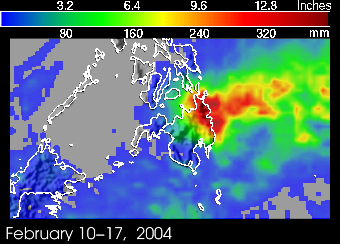
A second TRMM image, provided above, shows MPA rainfall totals for February 10-17, 2004. The highest totals are shown to be right over the DiuataMountains over the northeast part of the island where as much as 16 inchesof rain (darkest reds) are estimated to have fallen. Areas that receivedon the order of 10 inches of rainfall (red areas) cover most of northeasternMindanao and extend well out into the Philippine Sea. Amounts drop offsharply towards the western half of the island but are still on the orderof 5 inches over the central part of Mindanao.
TRMM is a joint mission between NASA and the Japanese space agency JAXA.
References & Resources
Images produced by Hal Pierce (SSAI/NASA GSFC) and caption by Steve Lang (SSAI/NASA GSFC).


