June 18, 2012
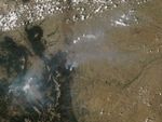
The High Park Fire, about 15 miles (24 kilometers) west of Fort Collins, Colorado, was discovered just before 6:00 a.m. on June 9, 2012. Started by lightning, the fire quickly grew, fueled by high winds and dry vegetation. By the morning of June 19, the fire had burned more than 58,770 acres (23,784 hectares) and destroyed 189 structures.
The Moderate Resolution Imaging Spectroradiometer (MODIS) on NASA’s Aqua satellite acquired this image at 1:40 p.m. local time (19:40 UTC) on June 18, 2012. Red outlines show the approximate boundaries of actively burning fires. Pyrocumulus clouds—cumulus clouds that cap columns of smoke and appear white—are visible.
References & Resources
- Inciweb. (2012). High Park Fire. Accessed Juune 19, 2012.
NASA image courtesy Jeff Schmaltz, LANCE MODIS Rapid Response. Caption by Adam Voiland.