






![Request for Information – Potential [Placeholder for Prize]](https://assets.science.nasa.gov/dynamicimage/assets/science/psd/solar/2023/09/s/solarsystem_0.jpg?w=1024)






August 7, 2012
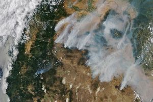
Sparked by lightning, the Holloway Fire had burned 112 square miles (291 square kilometers) near the Nevada-Oregon border by August 8, 2012. The fire is burning in grass and scrubland, close the same area that burned in July in the Long Draw Fire. This natural-color satellite image shows smoke from the fire blowing north. It was collected by the Moderate Resolution Imaging Spectroradiometer (MODIS) aboard the Aqua satellite on August 7, 2012. Actively burning areas, detected by MODIS’s thermal bands, are outlined in red.
References & Resources
- Oregonian. (2012, August 8) Fire Crews Report Good Progress on Containing Wildfires in Oregon and Washington. Accessed August 8, 2012.
- OregonLive. (2012, August 7) Wildfire From Nevada Burns into SE Oregon. Accessed August 8, 2012.
NASA image courtesy Jeff Schmaltz, LANCE MODIS Rapid Response. Caption by Adam Voiland.