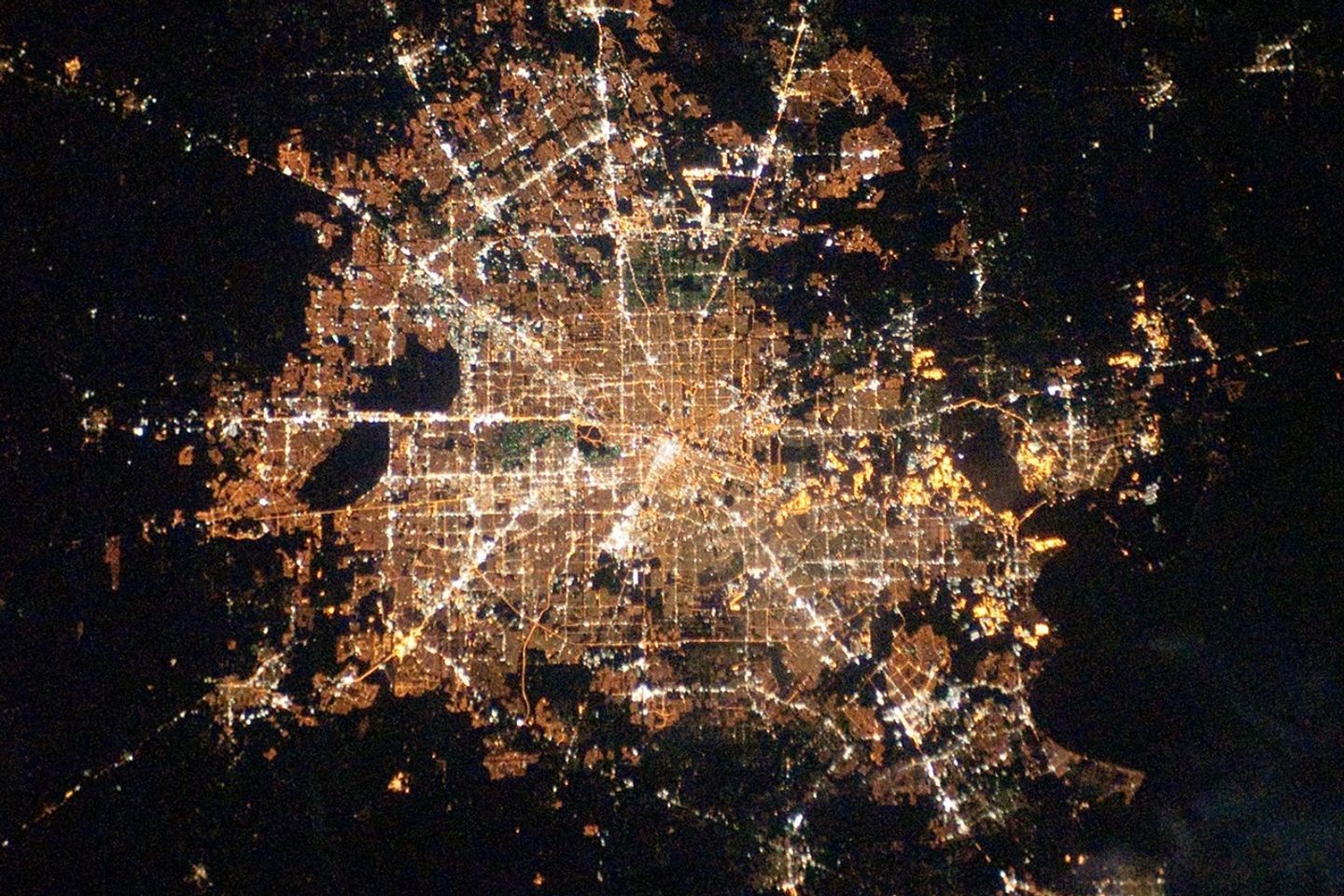


Houston, Texas, has been called the “energy capital of theworld” due to its role as a major hub of the petroleum and otherenergy resource industries. The Houston metropolitan area covers almost2,331,000 hectares (9,000 square miles) along thesoutheast Texas coastline, with an average elevation of 13 meters(43 feet) above sea level and a population of over 5million (2006 US Census estimate).
The Houston metropolitan area is alsonoteworthy as being the largest in the United States without formalzoning restrictions on where and how people can build. This freedom has led to a highly diverse pattern of landuse at the neighborhood scale; nevertheless, more general spatialpatterns of land use can be recognized in remotely sensed data. These general patterns are particularly evident in nighttime photography of the urban area taken byastronauts on board the International Space Station.
The image depicts the roughly 100-kilometer (60-mile) east-westextent of the Houston metropolitan area. Houston proper is at imagecenter, indicated by a “bull’s-eye” of ellipticalwhite- to orange-lighted beltways and brightly lit white freewaysradiating outwards from the central downtown area. Suburban andprimarily residential urban areas are indicated by bothreddish-brown and gray-green lighted regions, which indicate a higherproportion of tree cover and lower light density.
Petroleum refineriesalong the HoustonShip Channel are identified by densely lit areas of golden yellowlight. Rural and undeveloped land rings the metropolitan area, andGalveston Bay to the southeast (image lower right) provides access tothe Gulf of Mexico. Both types of non-urban surface appear dark in theimage.
You can see more nighttime imagery of cities and learn abouttechniques that astronauts use to photograph them in the EarthObservatory feature Citiesat Night.
References & Resources
Astronaut photograph ISS022-E-78463 was acquired on February 28, 2010, with a Nikon D3 digital camera and is provided by the ISS Crew Earth Observations experiment and Image Science & Analysis Laboratory, Johnson Space Center. The image was taken by the Expedition 22 crew. The image in this article has been cropped and enhanced to improve contrast. The International Space Station Program supports the laboratory as part of the ISS National Lab to help astronauts take pictures of Earth that will be of the greatest value to scientists and the public, and to make those images freely available on the Internet. Additional images taken by astronauts and cosmonauts can be viewed at the NASA/JSC Gateway to Astronaut Photography of Earth. Caption by William L. Stefanov, NASA-JSC.