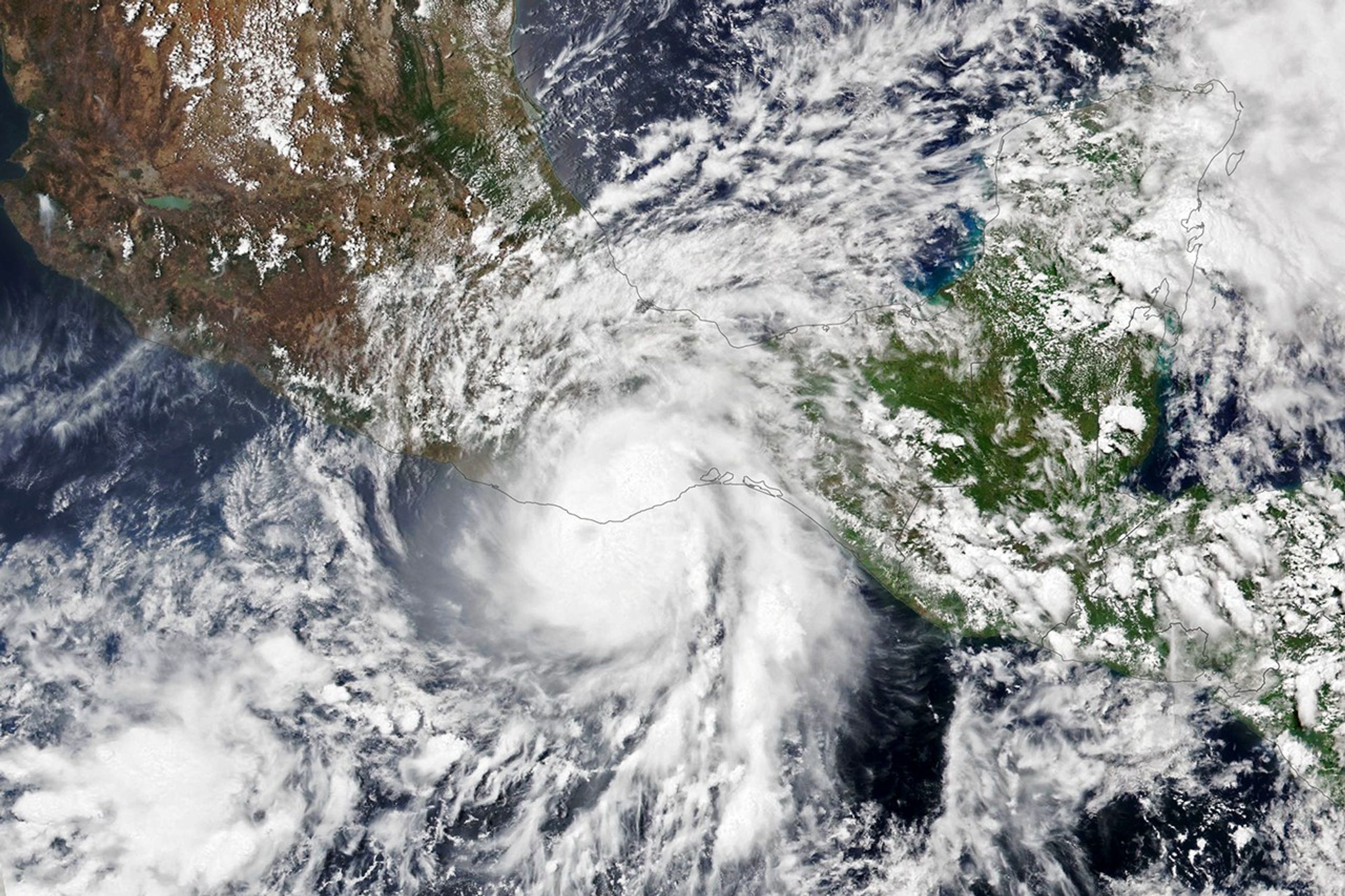


Hurricane season in the eastern Pacific is off to an early and potent start. Though May storms are rare there, Hurricane Agatha struck western Mexico, near Puerto Escondido, bearing maximum sustained winds of 105 miles (169 kilometers) per hour on May 30, 2022. That made the category 2 storm the strongest May hurricane to make landfall along the Pacific coast of Mexico since modern record keeping began in 1949, according to the National Hurricane Center.
The Visible Infrared Imaging Radiometer Suite (VIIRS) on the NOAA-20 satellite acquired this natural-color image of the storm at 1:35 p.m. local time (19:35 Universal Time) on May 30, 2022, a few hours before the storm made landfall. Agatha brought intense downpours and howling winds to several tourist beaches and fishing towns in an otherwise sparsely populated region before weakening rapidly as it moved northward over the mountainous terrain of southern Mexico.
Prevailing trade winds typically steer west and out to sea, but in this case a low-pressure trough dipped far enough south to pull Agatha toward land, reported meteorologist Jeff Masters for Yale Climate Connections. Hurricane forecasters are watching the possibility that Agatha’s remnants will become more organized and strengthen over the Gulf of Mexico as they move toward Florida.
NOAA and other federal and state agencies lead the task of forecasting and responding to hurricanes in the United States, with NASA playing a supporting role in developing experimental tools and providing key data to those agencies. NASA’s Earth Science Applied Sciences program works to streamline the flow of information to international science institutions, governments, and aid groups as they use and customize data products from freely available NASA data.
The eastern Pacific hurricane season officially runs from May 15 through November 30. The peak months of the season are July through September. NOAA’s seasonal outlook for the eastern Pacific hurricane season in 2022 indicates that a below-normal season is likely, while the seasonal outlook for the Atlantic Ocean predicts a more active season than normal. The ongoing La Niña and resulting changes in vertical wind shear in key regions of hurricane formation and development are one of the key factors behind these forecasts.
References & Resources
- My NASA Data Hurricane Dynamics. Accessed May 31, 2022.
- NASA Earthdata (2021) Cyclones Data Pathfinder. Accessed May 31, 2022.
- NASA Earthdata (2021) Tropical Cyclones Toolkit. Accessed May 31, 2022.
- NASA Earth Science Applied Sciences Mapping the Effects of Hurricanes & Cyclones. Accessed May 31, 2022.
- NASA (2021, June 2) NASA Scientists Available for Interviews Throughout Hurricane Season. Accessed May 31, 2022.
- NASA Earth Observatory (2017) El Niño.
- NOAA (2022, May 24) Eastern Pacific Hurricane Season Outlook. Accessed May 31, 2022.
- NOAA (2022, May 24) NOAA predicts above-normal 2022 Atlantic Hurricane Season. Accessed May 31, 2022.
- NOAA (2021, October 5) Impacts of El Niño and La Niña on the hurricane season. Accessed May 31, 2022.
- Tampa Bay Times (2022, May 21) âIt could happen fast:â Meteorologist tells Floridians to monitor Gulf system. Accessed May 31, 2022.
- Yale Climate Connections (2022, May 31) Agatha dissipates over Mexico after making landfall as strongest Pacific May hurricane. Accessed May 31, 2022.
NASA Earth Observatory image by Lauren Dauphin, using VIIRS data from NASA EOSDIS LANCE , GIBS/Worldview , and the Joint Polar Satellite System (JPSS). Caption by Adam Voiland .