


- 15 dBZ Isosurface (500 KB)
- Quicktime (.mov) format (2.0 MB)
As the cleanup from Hurricane Charley continues across Florida, yet anotherpowerful hurricane, Frances, is being closely monitored as the large, intensestorm continues moving westward towards the southeast coast of the U.S. TheTropical Rainfall Measuring Mission or TRMM satellite has been monitoring thesystem, sending back valuable images that help forecasters at the TropicalPrediction Center (also known as the National Hurricane Center) estimateFrances' location and intensity.
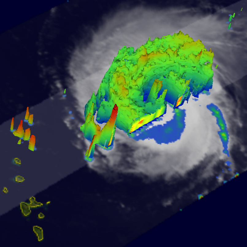
Frances became a tropical depression during the night of the 24-25th of August2004 about 900 miles southwest of the Cape Verde Islands. Cape Verde storms typically form closer to the coast of Africa fromtropical easterly waves during the height of the hurricane season as watertemperatures warm farther east across the Atlantic. Frances quickly organized,becoming a tropical storm the next day on the 26th and a hurricane the followingday on the 27th. Initially, Frances moved west-northwest but then took a slightturn towards the northwest as a midlatitude trough weakened the ridge that wasnorth of the storm and responsible for steering it westward. Conditions remainedideal for strengthing, however, and Frances intensified into a major Category 4hurricane by the evening of the 28th with maximum sustained winds estimated at115 knots (132 mph) by the National Hurricane Center. The next day Frances turnedback to a more westerly coarse as the midlatitude trough lifted out and thesubtropical ridge restrengthened north of the storm. August 30th also saw Francesweaken slightly possibly due to some southerly wind shear. Another factor in theintensity of major hurricanes is what as known as eyewall replacement. When thishappens, the storm intensity can fluctuate, weakening for a period as a new eyewallforms outside of the original, inner eyewall. Eventually, the outer eyewallcontracts, replacing the inner eyewall, which allows the storm to reintensify. The image displayed shows Frances northeast of the Leeward Islands at 10:21 UTC (06:21 am EDT)on the 30th of August. The image shows the horizontal distribution of rainintensity obtained from the TRMM satellite. Rain rates in the center part of theswath are from the TRMM Precipitation Radar (PR), the first and only precipitationradar in space. The PR can provide fine resolution rainfall data and details on thevertical structure. Rain rates in the outer swath are from the TRMM Microwave Imager(TMI). The rain rates are overlaid on infrared (IR) data from the TRMM VisibleInfrared Scanner (VIRS). At the time of this image, Frances was a Category 3hurricane with sustained winds of 105 knots (121 mph) as measured by an Air ForceReserve Hurricane Hunter Aircraft. TRMM shows the very beginning of an eyewallreplacement cycle. The innermost eyewall is visible by the small semicircle of heavy(red) to moderate rain (green) just west of the center. Surrounding that is aconcentric ring of moderate (green) to light (blue) rainfall that marks the beginningof a new eyewall.
The second image is from the same time and shows the height of the 15 dBZ isosurfaceas seen by the PR. This is associated with light rain but where hydrometeor sizesare becoming significant. The coloring indicates the height: red being high, greenmoderate and blue low. Here the inner eyewall is separated by the new outer eyewallby the minimum in the height of the 15 dBZ isosurface (blue area). The tall tower(red spike) southwest of the center is associated with an outer rainband.
TRMM is a joint mission between NASA and the Japanese space agency JAXA.
References & Resources
NASA images produced by Hal Pierce (SSAI/NASA GSFC) and caption by Steve Lang (SSAI/NASA GSFC), NASA's Tropical Rainfall Measuring Mission.


