


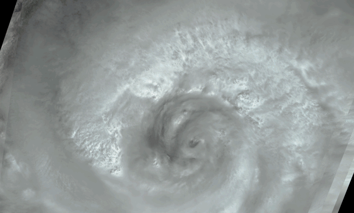
After causing widespread destruction on Puerto Rico, Haiti, and theDominican Republic, Hurricane Jeanne was weakened to Tropical Stormstatus for several days before it regained strength over the Bahamas asa Category 2 hurricane. When Jeanne made landfall in U.S. territory onSeptember 26, it was the fourth major hurricane of the 2004 Atlantichurricane season to strike Florida. These visualizations of HurricaneJeanne on September 24 were captured by NASA’s Multi-angle ImagingSpectroRadiometer (MISR). The still panels include a natural-color viewfrom MISR’s 26° forward-viewing camera (left) and atwo-dimensional map of cloud-top heights (right). In addition, a#8220;multi-angle fly-over” is provided as an animation usingviews from all nine MISR cameras.
The nine camera views which make up the animation were acquired over aninterval of about 7 minutes, and have been processed to give anapproximate perspective view. The cloud height map was produced byautomated computer recognition of the distinctive spatial features amongimages acquired at different view angles. Two-dimensional maps of cloudheight such as these offer an opportunity to compare simulated cloudfields against actual hurricane observations. Results indicate thatclouds within Jeanne had attained altitudes of more than 16 kilometersabove sea level. The height field pictured here is uncorrected for theeffects of cloud motion. Wind-corrected heights have higher accuracy butsparser spatial coverage.
The Multi-angle Imaging SpectroRadiometer observes the daylit Earthcontinuously and every 9 days views the entire globe between 82 degreesnorth and 82degrees south latitude. The MISR Browse Image Viewer provides access tolow-resolution true-color versions of these images. These data products were generatedfrom a portion of the imagery acquired during Terra orbit 25372. Thestill image panels cover an area of about 400 kilometers by 884kilometers, and utilize data from within blocks 68 to 71 and withinWorld Reference System-2 path 10.
References & Resources
Image courtesy NASA/GSFC/LaRC/JPL, MISR Team. Text by Clare Averill (Raytheon/JPL).


