


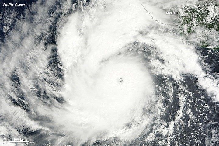
On October 6, 2011, a tropical depression over the eastern Pacific Ocean strengthened into Tropical Storm Jova. On October 8, it became a hurricane. By 11:00 a.m. Pacific Daylight Time (PDT) on October 10, 2011, the U.S. National Hurricane Center (NHC) reported that Jova was a Category 3 storm headed for the southwestern coast of Mexico.
The Moderate Resolution Imaging Spectroradiometer (MODIS) on NASA’s Terra satellite captured this natural-color image at 10:40 a.m. Pacific Daylight Time on October 10, 2011. Jova sports the spiral shape and distinct eye characteristic of strong storms. In the northeast quadrant, the storm’s clouds graze the coast of Mexico.
As of 11:00 a.m. PDT on October 10, Jova had maximum sustained winds of 125 miles (205 kilometers) per hour, and was located roughly 220 miles (255 kilometers) southwest of Manzanillo, Mexico. A hurricane warning was in effect from Punta San Telmo north to Cabo Corrientes, and a tropical storm warning was in effect for Lazaro Cardenas north to Punta San Telmo. The NHC stated that the storm could become a Category 4 hurricane before making landfall on October 11.
References & Resources
- National Hurricane Center. (2011, October 10). Hurricane Jova Advisory Archive. Accessed October 10, 2011.
NASA image courtesy MODIS Rapid Response Team, Goddard Space Flight Center. Caption by Michon Scott.


