Suggested Searches

1 min read

Hurricane Marie

Instruments:
2014-08-26 00:00:00
August 26, 2014

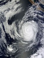
The Moderate Resolution Imaging Spectroradiometer (MODIS) on NASA’s Terra satellite acquired this natural-color image of Hurricane Marie and the remnants of Hurricane Karina on August 26, 2014. At the time, the storm had maximum sustained winds of 85 knots (97 miles per hour), making it a category 2 hurricane.

Marie has been churning up the eastern Pacific for nearly a week, creating heavy surf and some rainstorms along the coast of Mexico and Central America. However, it is not expected to make landfall. Read more about Marie on the NASA Hurricane Page.

References & Resources

NASA image by Jeff Schmaltz, LANCE/EOSDIS Rapid Response. Caption by Mike Carlowicz.

You may also be interested in:

Stay up-to-date with the latest content from NASA as we explore the universe and discover more about our home planet.

A Plume of Bright Blue in Melissa’s Wake
5 min read

The category 5 hurricane stirred up carbonate sediment near Jamaica in what scientists believe is the largest such event in…

Article
Tropical Cyclone Narelle Crosses Australia
3 min read

The powerful storm lashed the northern edge of the continent with damaging winds and drenching rain as it made landfall…

Article
A Second Cyclone Slams Madagascar
3 min read

Widespread flooding affected tens of thousands of people after cyclones Fytia and Gezani drenched the island.

Article