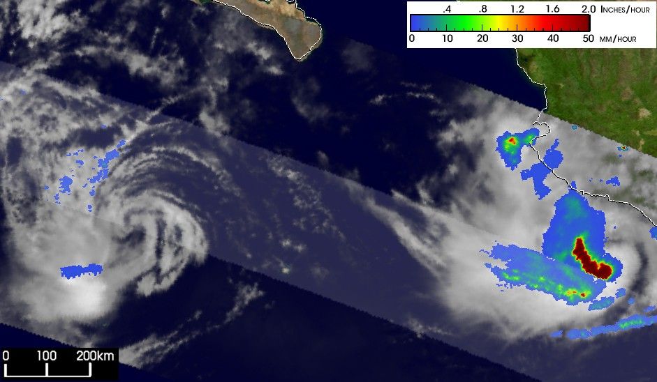

The Tropical Rainfall Measuring Mission (TRMM) satellite captured thisremarkable image of two tropical storms in the eastern Pacific--Nora andOlaf--in the same overpass. Taken on 6 October 2003 at 20:14 UTC, theimage shows Tropical Storm Nora on the left and Tropical Storm Olaf onthe right. Nora became a tropical storm on October 2 and strengthenedinto a Category 2 hurricane with estimated winds of just over 100 mph on the4th before weakening again into a tropical storm on the 6th. Olaf becamea tropical storm on the 3rd of October, a minimal Category 1 hurricane onthe 5th, and also weakened back to a tropical storm on the 6th.
The image shows an instantaneous snapshot of the rainfall rates forboth storms as seen by the TRMM Precipitation Radar (PR) in the innerswath and TRMM Microwave Imager (TMI) in the outer swath. The rainratesare overlayed on a visible image from the TRMM Visible Infrared Scanner(VIRS). Despite the impressive swirl of cloudiness, TRMM reveals that Norais devoid of any significant rainfall. The core no longer contains anyconvection to support the storm and indicates that Nora will likely continueto weaken. Olaf however does contain areas of intense rainfall (darker reds)that are helping to maintain the storm. However, due to its poororganization and close proximity to the west coast of Mexico, Olaf haslittle chance to strengthen much.
TRMM is a joint mission between NASA and the Japanese space agency NASDA.
References & Resources
Image produced by Hal Pierce (SSAI/NASA GSFC) and caption by Steve Lang (SSAI/NASA GSFC).