

While recent studies have shown that on the whole Arctic sea ice has decreasedsince the late 1970s, satellite records of sea ice around Antarctica reveal anoverall increase in the southern hemisphere ice over the same period. Continueddecreases or increases could have substantial impacts on polar climates, becausesea ice spreads over a vast area, reflects solar radiation away from the Earth’ssurface, and insulates the oceans from the atmosphere.
In a study just published in the Annals of Glaciology, Claire Parkinson ofNASA’s Goddard Space Flight Center analyzed the length of the sea ice seasonthroughout the Southern Ocean to obtain trends in sea ice coverage. Parkinsonexamined 21 years (1979-1999) of Antarctic sea ice satellite records anddiscovered that, on average, the area where southern sea ice seasons havelengthened by at least one day per year is roughly twice as large as the areawhere sea ice seasons have shortened by at least one day per year. One day peryear equals three weeks over the 21-year period.
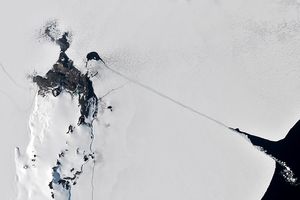
The image on the left shows the average number of days that the ocean surfacewas covered by sea ice from 1979 to 1999. The image on the right shows the changein duration of sea ice coverage over that period. Blue and green colors show areas wherethe sea ice is lasting longer, while orange and red colors represent a decrease in thenumber of days the ocean is frozen. The larger area covered by longer-lasting iceindicates an increase in the amount of Antarctic ice.
For more information, read:Satellites Show Overall Increases in Antarctic Sea Ice Cover
References & Resources
Images courtesy Claire Parkinson and the Laboratory for Hydrospheric Processes, NASA GSFC