


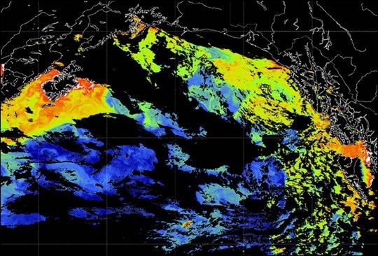
This Sea-viewing Wide Field-of-view Sensor (SeaWiFS) image shows chlorophyll concentrations in the northeastern Pacific Ocean. Chlorophyll is the primary pigment found in phytoplankton—it gives the tiny marine plants their greenish color and they use it for photosynthesis. By precisely measuring the colors of light reflected by the ocean, SeaWiFS allows scientists to measure concentrations of phytoplankton blooms. In this false-color image, reds and yellows show high concentrations while greens, light blues, and dark blues show progressively lower concentrations. Black shows areas of no data due to cloud cover over the ocean.
Note the patch of high chlorophyll concentration (yellow and red pixels) toward bottom center of the image. This patch was created by the SERIES Project (Subarctic Ecosystem Response to Iron Enrichment Study). By “seeding” the seawater with trace amounts of iron—the equivalent of one geritol tablet per hundred tons of sea water—scientists stimulated a fairly large phytoplankton bloom. In this patch, the chlorophyll levels are elevated from mid-ocean values of near0.3 milligrams per cubic meter (blue pixels in this image) to more than 3 milligrams per cubic meter (yellow and red pixels), which is typical of the more nutrient-rich waters closer to the continental shelves near Kodiak Island to the north (upper left), and the Queen Charlotte Islands to the east (lower right).
(Editor’s note: read the biography on John Martin to learn more about the Iron Hypothesis.)
The Gulf of Alaska is extremely cloudy, especially in June and July of eachyear. This image was acquired on July 29, 2002, and is the only example foundso far of a satellite image of the patch. Twenty days after the first ironinjection, the patch is clearly visible as an area about 30 km across. The patch remained surprisingly compact through this period.
In the experiment, iron was added to an 8-km-square area of surface water near Weather Station Papa at 50N latitude by 145W longitude on July 9, 2002, to stimulate phytoplankton growth, and more iron was added into the same patch on July 16. The iron was added from the Canadian research vessel John P. Tully, which stayed to track and measure the patch until July 23. The Mexican research vessel, El Puma, chartered by Canadian scientists, measured the evolution of plankton communities in the patch and associated gas exchanges from July 9 to July 28. A Japanese research vessel, Kaiyo Maru, then arrived at the patch on July 23 and stayed until August 4. Their measurements of patch position and shape on July 29 agree very precisely with this image.
SERIES was funded jointly by Japan and the Canadian SOLAS (Surface OceanLower Atmosphere Study). The project was designed to study the exchanges of gas between the ocean and atmosphere, and to assess the amount of carbon removed from the atmosphere by the addition of iron. More importantly, scientists also want to gauge the amount of carbon that eventually sinksinto the deep ocean, thus making a small, but long-term contribution to reducing the carbon dioxide content of the atmosphere.
The patch was seeded at 50 N, 144.7 W on July 9. It moved north to 50.6 Nby July 21, and on July 29 it was at 50.9 N, 144.2 W. It was last seen by the Kaiyo Maru on August 4 traveling east at about 3.5 km per day. Additional visible or infrared satellite images in August 2002 would be extremely useful for assessing the fate of the patch. Anyone sighting this chlorophyll patch in archived remote sensing data is asked to contact Jim Gower, of Canada’s Institute of Ocean Sciences, Sidney British Columbia.
References & Resources
Data courtesy NASA SeaWiFS Project . Image provided by Jim Gower, Institute of Ocean Sciences, Sidney BC, the IOS SERIES team, and Bill Crawford and Frank Whitney, Institute of Ocean Sciences, Sidney BC.


