

2000 - 2009
Is That a Forest? That Depends on How You Define It
After comparing eight satellite-derived global maps, researchers found that measurements of forest cover vary widely—as much as 6 percent of Earth’s land area, or the equivalent area of China. But the biggest discovery was not the discrepancy; it was the reason behind it.
Using the first global, Landsat-based map of tree cover (at 30-meter resolution), researchers led by Joseph Sexton of the University of Maryland found that ambiguity in the use of the word “forest” leads to different assessments of the location and extent of forest cover on maps. Ecologists have long understood the complexity and vagueries of the concept of “forest.” Geographers have long called for the definition to be more standardized across national and international monitoring entities. But until now, no one had quantified the scope of the problem.
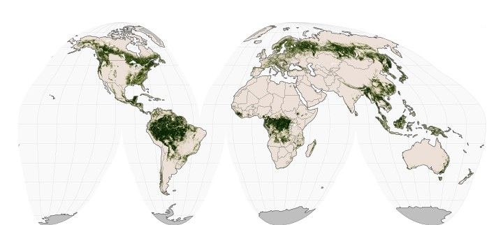
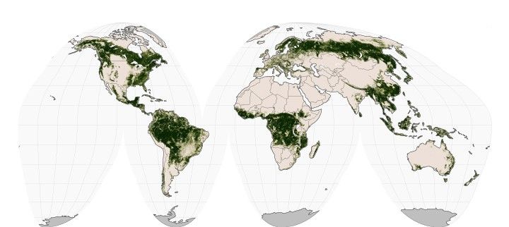
The maps of forest cover above illustrate how measurements can vary widely depending on the forest definition used. The two maps are based on Landsat data and use different definitions employed by the UN Framework Convention of Climate Change (UNFCCC). The top map considers an area forested if 30 percent of the land is covered with trees; the second map claims a “forest” when there is 10 percent tree cover. The difference in forest calculations derives mainly from areas of intermediate tree cover, such as savannahs, shrublands, mountain ridge forests, and boreal taiga. (Use the image comparison tool to see where major measurement differences occur.)
“Whereas previous studies mentioned the discrepancy, our analysis quantified and mapped it globally and connected it to estimates of biomass and economic value,” said Sexton, who is part of UM’s Global Land Cover Facility. The findings were published in Nature Climate Change.
Issues such as persistent cloud cover in the tropics, shadows from the tree canopy, and the complexity of forest structure can all lead to small errors in satellite-based forest maps. But those errors are small in comparison to those caused by the definition problem. “It’s not technology’s fault” that forest maps are inconsistent, Sexton said. “Today’s satellites provide us with a sufficient precision to make ecological measurements of forests.”
But until the definitions get hammered out, it will be difficult to make proper land-cover assessments or conservation agreements related to greenhouse gas emissions, climate change, and biodiversity. Sexton and colleagues propose that there should either be a single, unambiguous definition of forest/non-forest that can be used globally or, preferably, the research and conservation community should shift to maps of measureable ecological characteristics such as tree cover, canopy height, and biomass.
“Through advances in remote sensing, we increasingly have the technical capacity to estimate the structure, cover, and composition of terrestrial ecosystems from space,” Sexton explained. If an international consortium of scientists agreed on a set of measurable forests characteristics, better estimates of carbon stocks (where and how much carbon is stored in vegetation) could be made.
References & Resources
- Sexton, J.O. et al. (2015) Conservation policy and the measurement of forests. Nature Climate Change, advance online publication.
- NASA Earth Observatory (2015, May 7) Mapping Forest Loss with Landsat.
- NASA Earth Observatory (2013, November 16) New Map Yields Better View of Forest Changes.
- CIFOR Forests News (2015, August 4) Counting trees: 143 scientists just did. Accessed November 16, 2015.
- Skidmore, A.K. et al. (2015, July 22) Agree on biodiversity metrics to track from space. Nature, 523, 403–405.
NASA Earth Observatory images by Jesse Allen, using data provided by the University of Maryland’s Global Land Cover Facility. Caption by Laura Rocchio, with Mike Carlowicz.