


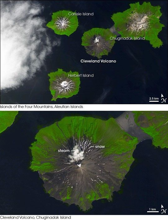
In the northern Pacific Ocean off the southwest coast of Alaska, the planet is building new land. Arcing southwestward from Alaska like the tail of a kite, the Aleutian Islands are a string of active and dormant volcanoes fed by magma created by the collision of the Pacific Plate with the North American Plate. In the northeast part of the range, a cluster of summits known as the Islands of the Four Mountains is home to Cleveland Volcano, one of the Aleutians’ most frequently active volcanoes.
This image of the central part of the Islands of the Four Mountains group was captured by the Advanced Spaceborne Thermal Emission and Reflection Radiometer (ASTER) on NASA’s Terra satellite on July 27, 2007. In the center of the image, Cleveland Volcano is connected to Chuginadak Volcano by a thin strip of land that appears to be barely above sea level in places. Together these mountains make up Chuginadak Island.
Vegetation on the lower slopes of the mountains is bright green, while bare rock is charcoal-colored. Even so late in the summer, snow streaks the summits. Although no ash clouds or fresh lava flows are visible, more subtle signs of recent activity at Cleveland Volcano do exist. A close-up view of the summit (lower image) shows a cloud that aerial photography confirmed was a steam plume. The other obvious sign of recent activity is the near absence of snow on the mountain. Cleveland’s slopes are almost completely bare, while neighboring summits—all of which are lower in elevation—are capped with snow. Heat from the volcano frequently melts the snow pack on Cleveland.
Scientists at the Alaska Volcano Observatory keep track of activity in the Aleutian Islands for scientific and practical purposes: ash eruptions can create hazards for airplanes, which frequently pass through the area on their way from North America to Asia and Europe. The scientists use a combination of seismic data, Webcams, field visits, aerial photography, and satellite observations to do their jobs. At the time it captured this image, ASTER also collected thermal infrared data (not pictured) that documented that the crater was still warm (41 degrees Celsius, or 106 Fahrenheit) when Terra passed overhead.
You can download a 15-meter-resolution KMZ file of the Islands of the Four Mountains suitable for use with Google Earth.
References & Resources
- Alaska Volcano Observatory. Maps of Cleveland Volcano.Accessed August 23, 2007.
- U.S. Geological Survey.Major Tectonic Plate of the World. Accessed August 23, 2007.
- Volcano World. Cleveland Volcano Information. Accessed August 23, 2007.
NASA image created by Jesse Allen, using data provided courtesy of NASA/GSFC/METI/ERSDAC/JAROS, and U.S./Japan ASTER Science Team.


