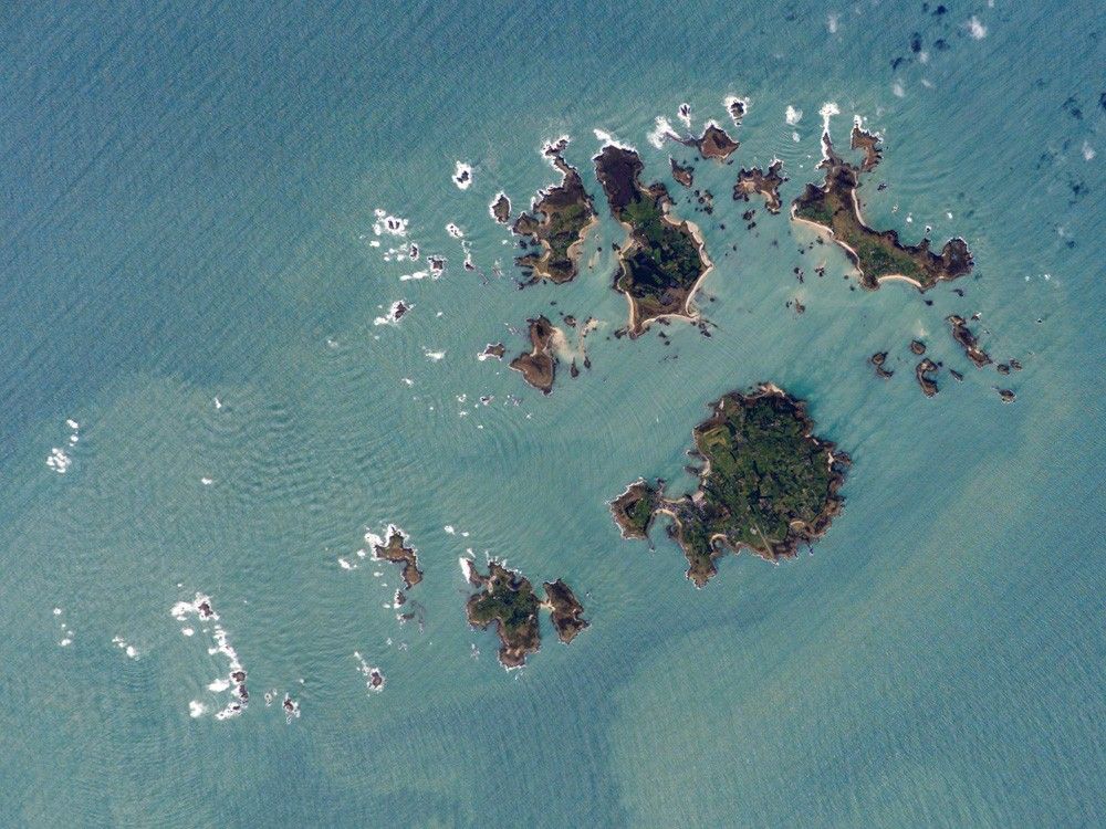

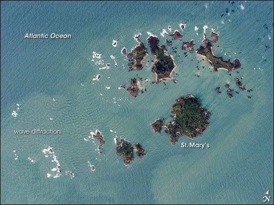
The Isles of Scilly, an archipelago of approximately 150 islands, are located some 44 kilometers southwest of the westernmost point of England (Land’s End). The islands are an eroded remnant of granite rock that intruded into the Earth’s crust from deeper underground. They have been inhabited for over 4,000 years, and historical and geological evidence on the Isles indicates that many of the islands were larger and/or connected in the recent past. Local subsidence (sinking) or rising sea level—or both—made the connections among the islands possible. Even today, it is possible to walk between certain islands during low tides.
This astronaut photograph illustrates the geographic configuration of the archipelago and its effect on ocean wave patterns. Long, linear swells oriented northeast-southwest and moving to the southeast (from image upper left to lower right) are diffracted (bent) as they approach the coastlines and small shoals of the Isles. The wave diffraction forms complex interacting surface patterns that are most clearly visible southwest of St. Mary’s island (image left). The dominant ocean wave pattern resumes to the southeast of St. Mary’s, but with an additional northwest-southeast pattern superimposed, possibly due to winds originating in the English channel to the east (not shown). Suspended, tan-colored sediments visible within and around the archipelago come from wave erosion of the granite that forms the islands and from remobilization of beach sands. Bright white areas in the photograph are waves breaking on shoals.
The Isles have been designated a United Kingdom Area of Outstanding Natural Beauty due to their unique landscape, ecology, and historical significance. The potential effect of rising sea level on the Isles is a primary concern for both long-term ecosystem health and human habitability.
References & Resources
Featured astronaut photograph ISS014-E-16597 was acquired on March 10, 2007, with a Kodak digital camera using a 400 mm lens, and is provided by the ISS Crew Earth Observations experiment and the Image Science & Analysis Laboratory, Johnson Space Center. The image in this article has been cropped and enhanced to improve contrast. The International Space Station Program supports the laboratory to help astronauts take pictures of Earth that will be of the greatest value to scientists and the public, and to make those images freely available on the Internet. Additional images taken by astronauts and cosmonauts can be viewed at the NASA/JSC Gateway to Astronaut Photography of Earth.