


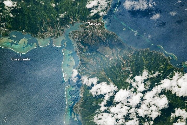
This photograph, taken by an astronaut onboard the International Space Station, provides a glimpse of the settlements along the shores of the coral reef-ringed island of Tahiti. Pictured here is the Isthmus of Taravao, a narrow strip of land that connects the two ancient volcanoes—Tahiti-Nui and Tahiti-Iti—and the villages that line the coast.
Tahiti is part of an archipelago in the Pacific Ocean called the Society Islands, one of five archipelagos that make up French Polynesia. Of the 118 islands and atolls, Tahiti is the largest, with approximately 70 percent of the nation’s population. This island’s rugged topography and dense rainforest has led most of its inhabitants to live along the coastline.
As with many islands in the South Pacific, the economy is driven in large part by tourism, so resorts and hotels have been built up along the coast. A constant environmental issue that Tahitians face is the rise of sea level and other climate-driven effects on coastal systems. The loss of shoreline from coastal flooding and erosion is a significant threat to low-lying communities and islands, and they could eventually have serious implications for Tahiti.
Find more stories about our changing oceans and coasts in Earth Observatory’s sea level rise collection. Learn more about astronaut photography in our new video feature Picturing Earth: Window on the World.
References & Resources
Astronaut photograph ISS061-E-26010 was acquired on October 31, 2019, with a Nikon D5 digital camera using an 800 millimeter lens and is provided by the ISS Crew Earth Observations Facility and the Earth Science and Remote Sensing Unit, Johnson Space Center. The image was taken by a member of the Expedition 61 crew. The image has been cropped and enhanced to improve contrast, and lens artifacts have been removed. The International Space Station Program supports the laboratory as part of the ISS National Lab to help astronauts take pictures of Earth that will be of the greatest value to scientists and the public, and to make those images freely available on the Internet. Additional images taken by astronauts and cosmonauts can be viewed at the NASA/JSC Gateway to Astronaut Photography of Earth. Caption by Laura Phoebus, Jacobs, JETS Contract at NASA-JSC.


