


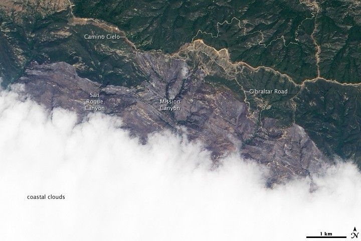
On Sunday, May 10, 2009, California firefighters got a break from the weather when a marine inversion layer calmed activity at the Jesusita Fire, north of Santa Barbara. The fast-moving blaze had destroyed at least 137 structures as of May 11, according to the daily situation report from the National Interagency Fire Center. The fire had affected an estimated 8,733 acres, but it had not grown in the previous 24 hours. Firefighters estimated the blaze was about 65 percent contained.
This natural-color image from the Advanced Land Imager on the Earth Observing-1 (EO-1) satellite on May 10 shows the northern part of the burned area, which stretches from the outskirts of Santa Barbara (hidden beneath clouds) into Los Padres National Forest. The image is roughly centered on Mission Canyon; investigators think the fire was started from power tools being used along the Jesusita Trail, between Mission Canyon and Roque Canyon, to the west. The burn scar appears grayish purple, and it stretches northward to the Camino Cielo highway that runs west to east across the top of the scene. Many valleys throughout the burned area appear to have been spared; green vegetation lines them like the veins in a leaf.
References & Resources
- National Interagency Fire Center. (2009, Mary 11). Incident Management Situation Report: May 11 (pdf). Accessed May 11, 2009.
- InciWeb. (2009, May 11). Special Announcement: Fire investigators have confirmed the Jesusita fire origin is adjacent to the Jesusita Trail. Accessed May 11, 2009.
NASA image created by Jesse Allen, using EO-1 ALI data provided courtesy of the NASA EO-1 Team. Caption by Rebecca Lindsey.


