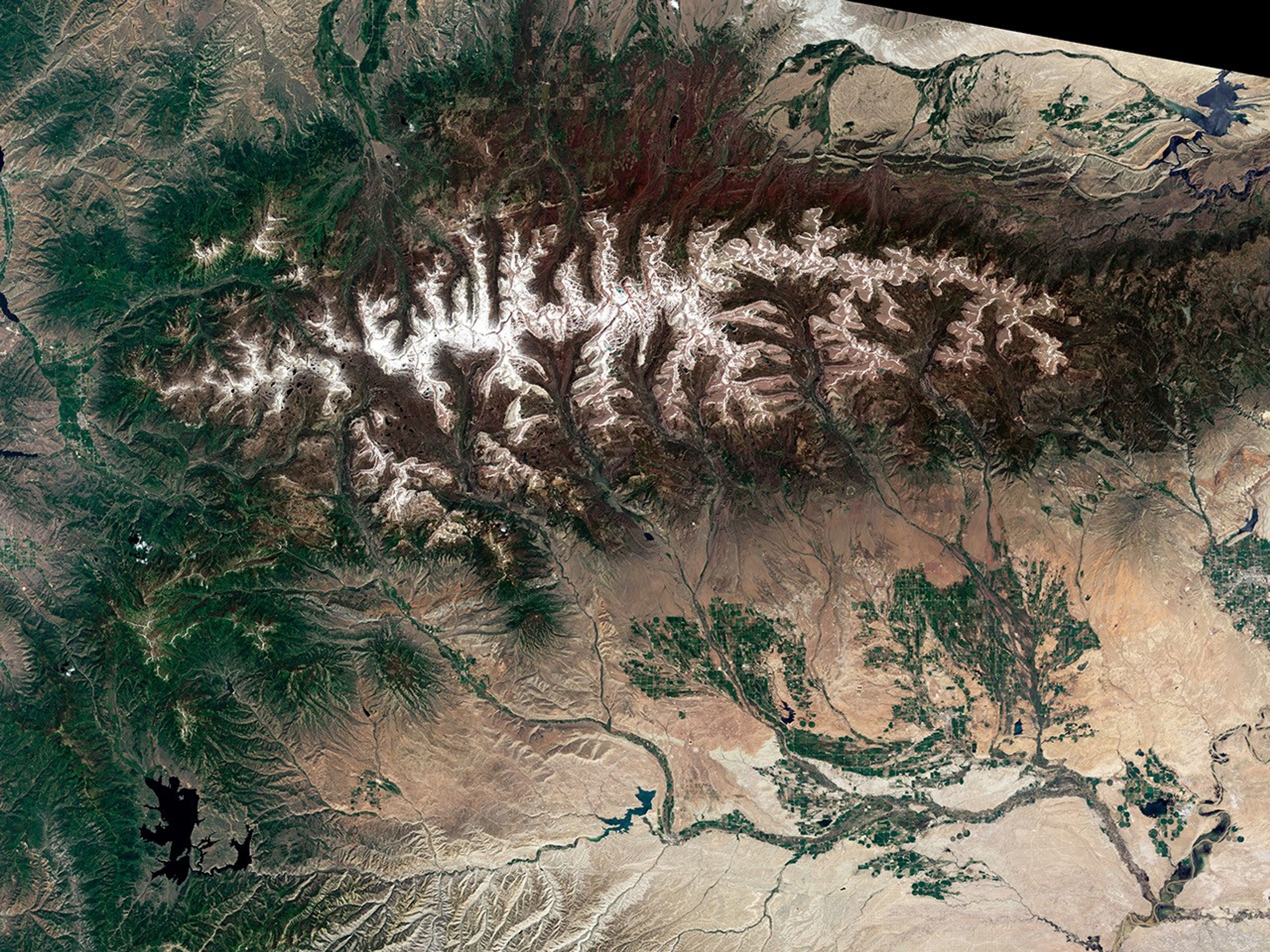

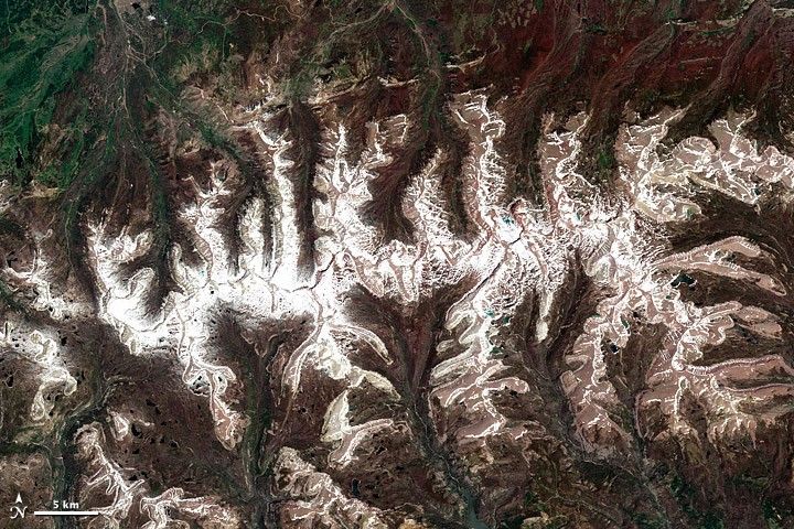
By July in a typical year, the snow that covers the slopes of the RockyMountains has given way to grasses and wildflowers, leaving only the peakscapped in white. But 2011 has not been a typical year. As this image of theUintaMountains in northeast Utah shows, winter’s snow is lingering intosummer. On June 26, the snowpack on the southern face of the range was 849 percent above average. The northern face had 892 percent more snow than average.
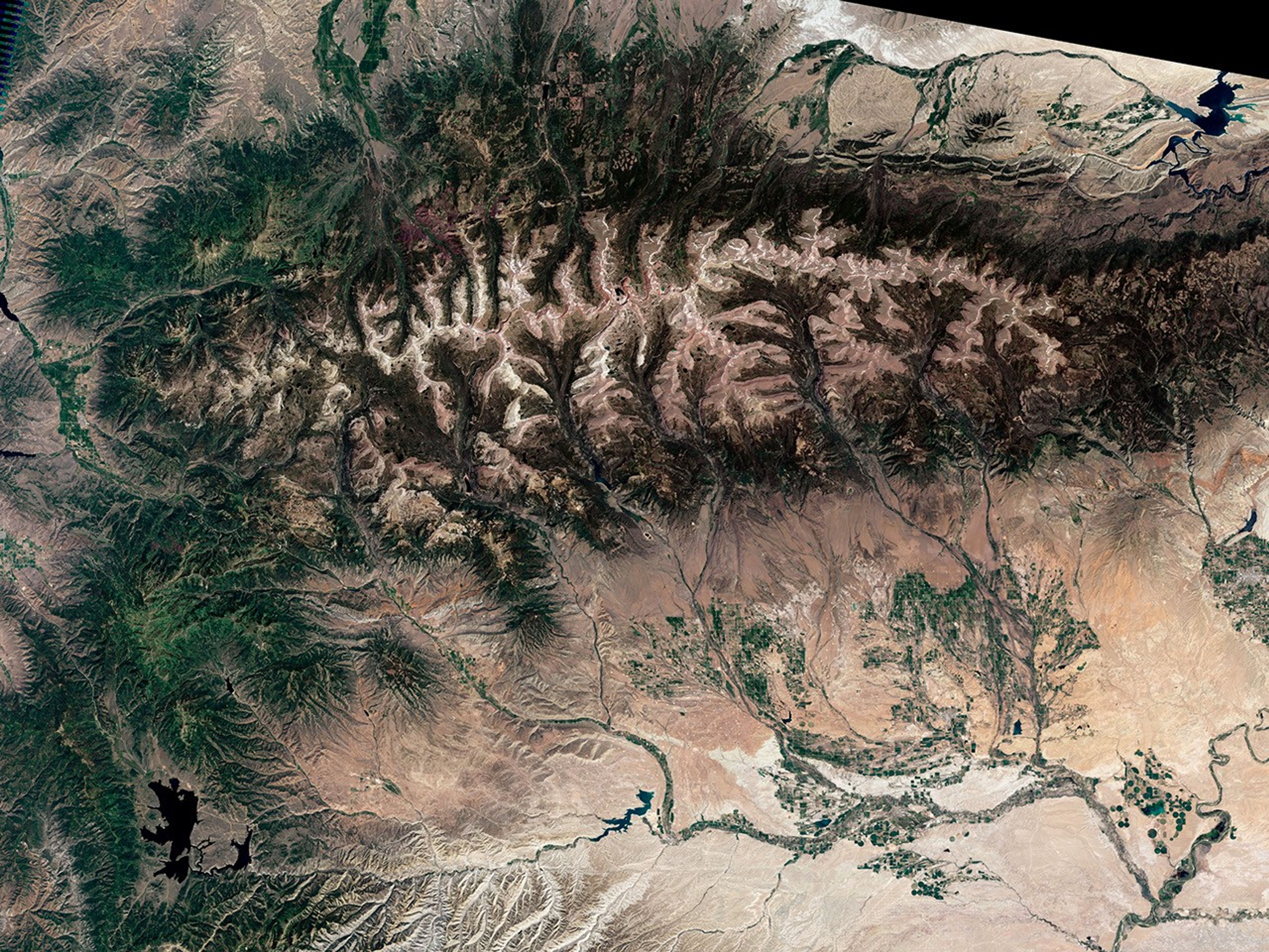
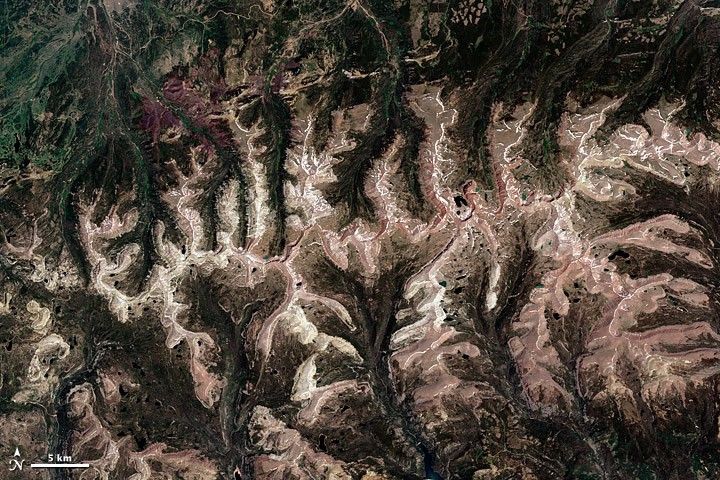
The image was taken by the Landsat 5 satellite on July 15, 2011. Thelower image, also from the Landsat 5 satellite, shows more representativeconditions on July 9, 2003. In the lower image, snow snakes along the highridgelines, while the slopes are bare. Snow is a much more dominant part ofthe scene in 2011.
The Uintas are typical of conditions throughout the northern Rockies andnorthwestern United States. From Montana to California, the extent oflingering snow is “exceptionally unusual,” said the NationalClimate and Water Center, who reports that snowmelt is usually completeby July.
A cool spring is part of the reason that the western mountainsstill hold snow in July. Washington and Oregon experienced the coldest Aprilto June on record, and other western states experienced temperatures belowor much below normal. With low temperatures, mountain snow didn’t meltquickly.
The other reason the snowpack is lasting into summer is that there wasmore snow to melt. The winter and spring of 2010-2011 brought far more snowthan average, leading to a record mountain snowpack in at least five states.A healthy snowpack is a boon to western states most of time. Snow storeswater for use in the dry summer months. However, if the snow melts quickly,the runoff could cause floods. Already, melting snowcontributed to floodingin the Missouri River basin. As the snowmelts in other basins, it could swell rivers with unseasonal floods.
Despite the record snow in some western states, the snow extent in NorthAmerica as a whole was below average in the spring (March to May) for the eighthyear in a row. The extent was low because less snow fell in central andnorthwestern Canada and Alaska than average.
References & Resources
- Johnson, K. and McKinley, J. (2011, May 21). Record snowpacks could threaten western states. New York Times.Accessed July 21, 2011.
- National Climate Data Center. (2011, June). State of theclimate: Global snow and ice for May 2011. National Oceanic andAtmospheric Administration. Accessed July 21, 2011.
- National Climate Data Center. (2011, July). State of the climate:National overview for June 2011. National Oceanic and AtmosphericAdministration. Accessed July 21, 2011.
- National Climate Data Center. (2011, July 12). Temperature and precipitationmaps April – June 2011. National Oceanic and AtmosphericAdministration.
- Natural Resources Conservation Service. (2011, June 26). SNOTELbasin time series snowpack summary graphs. United States Department ofAgriculture. Accessed July 21, 2011.
- Natural Resources Conservation Service. (2011, June 10). USDA provides emergency watershed protection program funds to protectfive western states from potential flood damages. United StatesDepartment of Agriculture. Accessed July 21, 2011.
- Natural Resources Conservation Service. (2011, July 14). Weeklyreport – snowpack/drought (& flood) monitor update. UnitedStates Department of Agriculture. Accessed July 21, 2011.
- U.S. Army Corp of Engineers. (2011, July 11). Corps: June 2011 was highest single month of runoff into Missouri Riverbasin. Accessed July 21, 2011.
NASA Earth Observatory image by Robert Simmon, using Landsat data from the Landsat Project Science Office. Landsat is jointly managed by the U.S. Geological Survey and NASA. Caption by Holli Riebeek.