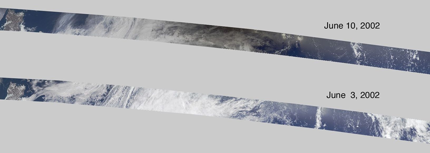

On June 10, 2002, the moon obscured the central portion of the solar disk in a phenomenonknown as an annular solar eclipse. Partial phases of the eclipse were visible throughoutmuch of southeast Asia and North America. Maximum obscuration, in which 99.6 percent ofthe solar disk was shadowed by the moon, occured in the central Pacific Ocean.Since there are no populated islands within 2,000 kilometers of this location,very few people were able to witness near-totality. The effect of the eclipse wascaptured in imagery of the central Pacific Ocean by the Multi-angle ImagingSpectroRadiometer (MISR) instrument onboard the Terra satellite.
This pair of images compares a view acquired during the eclipse (top) with a viewcaptured seven days earlier (bottom) that utilizes data from an adjacent orbitalpath and contains similar cloud forms. The region darkened by the eclipse is visible inthe upper image, with the darkest area to the right of center. The region in shadow atthe upper edge is situated about 600 kilometers northwest of the center line of theeclipse and captures the event about 11 minutes before its maximum. At this time andlocation, the moon is estimated to obscure about 75 percent of the solar disk.
The Terra satellite orbits Earth from pole to pole, descending from the northern latitudeson the daylight side. For a pictorial representation of the Terra satellite's polarsun-synchronous orbit, see the MISR orbit animation athttp://www-misr.jpl.nasa.gov/introduction/pictorial.html. The scenes shown here are longsegments of MISR image swaths; they represent an area of about 7180 kilometers by 380 kilometersand are rotated so that north is toward the left and south toward the right. Thebrownish landmass at the left-hand edge is Russia's Chukotskiy Peninsula, andthe right edge ends about 5 degrees north of the equator in the central Pacific.
The two scenes are geolocated to adjacent paths within World Reference System-2. The June 3 andJune 10 orbits utilize data from paths 86 and 87, respectively, and were acquired during Terraorbits 13086 and 13188. They utilize data from MISR blocks 36 to 86. MISR was built and ismanaged by NASA's Jet Propulsion Laboratory, Pasadena, CA, for NASA's Office of Earth Science,Washington, DC. The Terra satellite is managed by NASA's Goddard Space Flight Center,Greenbelt, MD. JPL is a division of the California Institute of Technology.
References & Resources
Image provided by NASA/GSFC/LaRC/JPL, MISR Team