


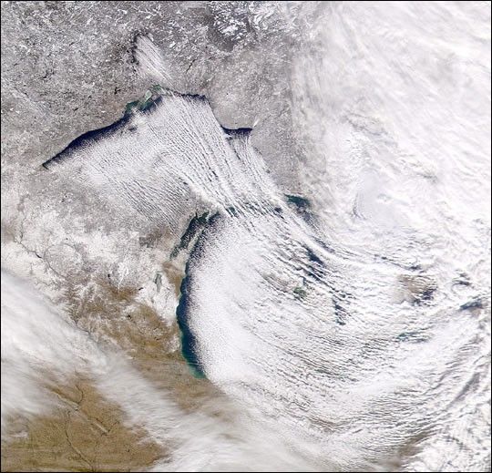
The lake effect is particularly clear in this Sea-viewing Widefield-of-view Sensor (SeaWiFS) true-color image of the North AmericanGreat Lakes region, acquired December 5, 2000. Lakes Nipigon, Superior,and Michigan show striking contrasts between clear and cloudy air as thewind blows from the northwest across the lakes.
As it flows across the relatively warm lakes, the cold dry air gathersheat and moisture from the surface. The warm moist air rises into theatmosphere and mixes vigorously with the cold dry air above. The layerof warm moist air deepens as it travels across the lake. Some of theevaporated water from the lake condenses into streamers of fog risingfrom the surface, while much of the moisture condenses to form astratocumulus cloud in the upper half of the mixed layer.
The cloud-forming water droplets may freeze into ice crystals and, dueto accumulated water deposition over time, grow into snowflakes. Thisprocess can generate snowstorms that produce significant amounts ofsnowfall downwind. It is not uncommon for lake effect snowstorms toproduce as much as two feet of snow within a 24-hour period innorthwestern parts of New York and Pennsylvania.
References & Resources
Image provided by the SeaWiFS Project, NASA/Goddard Space Flight Center, and ORBIMAGE


