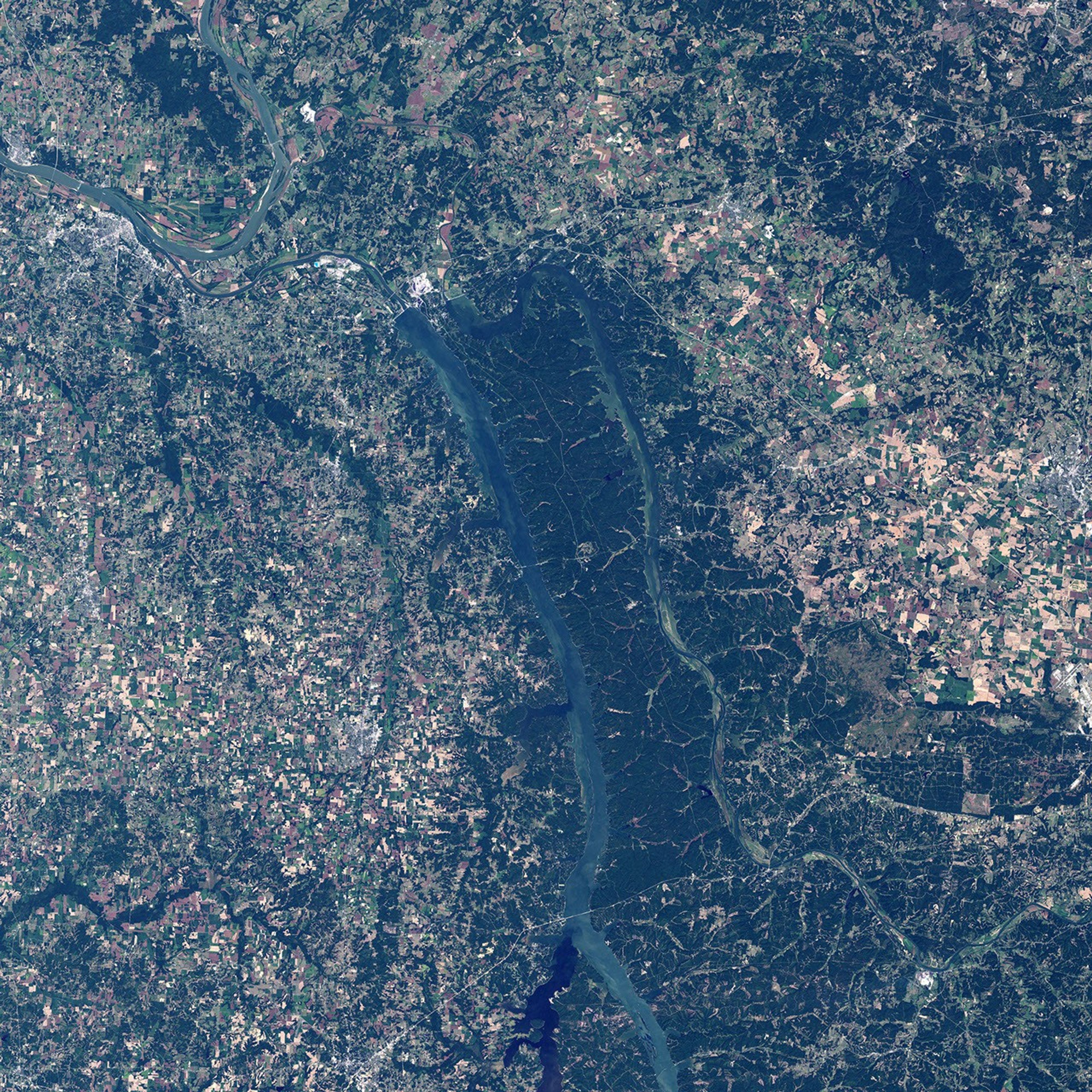
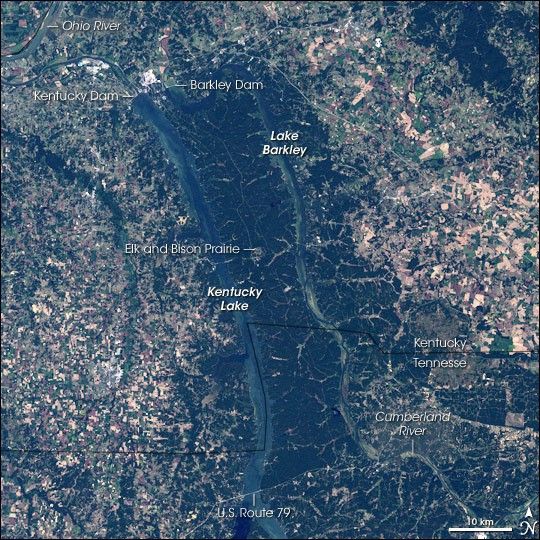
The Land Between The Lakes National Recreation Area sits nestled between two artificial lakes, Kentucky Lake and Lake Barkley, created by dams placed across the Tennessee and Cumberland Rivers, respectively. The dams created a peninsula in Kentucky and Tennessee that is surrounded on three sides by the lakes that connect with each other at the northern end of the parkland. The southern end of the peninsula is defined by U.S. Route 79.
This natural-color Landsat 7 satellite image shows the Land Between The Lakes National Recreation Area and the land around the park in Kentucky and Tennessee. The most striking features in the landscape are the two deep blue lakes that wrap around the green forested region between them. Surrounding the area is a checkerboard of development and agricultural lands. Roads and clearings crisscross the forest: when the National Recreation Area was created, the area had a number of small towns and historic settlements, which were gradually moved out of the protected land. Roads predating the park in some instances were abandoned, but others have been modernized to allow access for campers and explorers. Abandoned furnaces can be found throughout the park where small-scale iron smelting was done by local settlers in the 18th and 19th centuries.
The 700-acre Elk and Bison Prairie in the center of the parkland recreates the prairie ecosystem that dominated the landscape before European settlers arrived. Ecologists believe that the area was probably at the far eastern edge of the vast Great Plains, an ecosystem where frequent fires would have suppressed trees and maintained a mix of fast-growing grasses and wildflowers. Planting of crops and fire suppression by European settlers allowed trees to gain the upper hand, and now the area is forest covered.
President Kennedy designated this area a National Recreation Area in 1963 as a demonstration site to explore how an area with limited value for agricultural or timber harvesting and no major industrial activity could be transformed into an economically productive recreation area. Despite the success of the experiment, Land Between The Lakes remains the nation’s sole recreation demonstration site. It has become a tourist draw with roughly 2 million visitors each year, and it is the cornerstone in the local tourism industry, which brings hundreds of millions of dollars annually to the area. Kentucky Dam was created as part of the Tennessee Valley Authority, and it regulates the flow of water into the Ohio and Mississippi Rivers. Construction began in 1938, and it first started impounding water in the new Kentucky Lake in 1944. The Barkley Dam was built in the early 1960s for further flood control and to generate hydroelectricity.
This satellite image was obtained on September 17, 2000, by NASA’s Landsat 7 Enhanced Thematic Mapper Plus instrument.
- Further Reading
- Land Between The Lakes National Recreation Area from the U.S. Department of Agriculture Forest Service
- Land Between The Lakes National Recreation Area from Recreation.gov
- Kentucky and Barkley Lakes from Kentucky Lake Online
- Tennessee Valley Authority (TVA home page)
References & Resources
NASA image created by Jesse Allen, Earth Observatory, using data obtained from the University of Maryland’s Global Land Cover Facility .