


![Request for Information – Potential [Placeholder for Prize]](https://assets.science.nasa.gov/dynamicimage/assets/science/psd/solar/2023/09/s/solarsystem_0.jpg?w=1024)


Large Images:
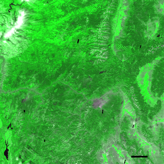
July 2000
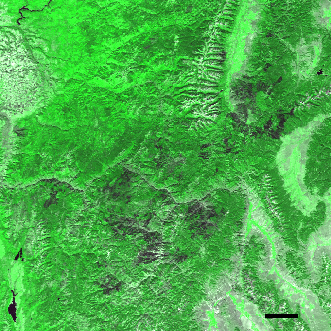
September 2000
BurnedArea
In the aftermath of one of the most devastating fire seasons in 100years, the U.S. Forest Service is embarking on a massive rehabilitationproject in the Northern and Intermountain West. With over 2 millionacres burned in Montana and Idaho, the expected Burned Area EmergencyRehabilitation costs are close to $20 million dollars for those statesalone.
Preliminary assessments of the extent and severity of burned areaswere made through observations from firefighters in the field and viaForest Service airborne instruments, but satellite observations such asthose acquired by NASA’s Moderate-resolution ImagingSpectroradiometer (MODIS), aboard the Terra satellite, provide more comprehensive evaluations of sucha large burned area. The results shown here are based on data acquiredby MODIS in July and September 2000.
These images are a demonstration of MODIS’s Vegetative CoverConversion (VCC) product, which uses MODIS’ 250-meter resolutionbands to assess changes in the type and amount of vegetation atlocations on the Earth’s surface on a monthly basis. The 250-mbands detect light in the red and near-infrared portions of theelectromagnetic spectrum. The VCC product detects change based on twocharacteristics of the red and infrared radiation that the Earthreflects onto MODIS’ detectors: brightness and greenness.
The brightness, or intensity, of radiation reflected from bare groundis high because there is nothing to absorb it. A dense forest, on theother hand, absorbs most of the incoming red radiation, so itsbrightness is low. The light that a forest doesn’t absorb well isinfrared, and so heavily vegetated areas reflect a high proportion ofinfrared light. The combination of low red and high infrared reflectanceis often referred to as "greenness."
The VCC product classifies five types of land cover based ondifferent combinations of brightness and greenness: forest, non-forest,bare ground, flooding, and burn scar. A forest is low brightness, highgreenness. When the forest is cleared for agriculture or urbandevelopment it shows the high brightness and low greennesscharacteristic of bare ground. So how does the VCC product detectrecently burned forested land, like in these images of theIdaho/Montana border region? By detecting when a point on the groundgoes from low brightness/high greenness to low brightness/low greenness,MODIS can tell where dark, partially burned vegetation has replacedgreen vegetation.
In these visualizations, the VCC product has identified several largeburn scars, which stand out in deep green against the brighter green ofthe remaining forest. The area shown includes the Clear Creek, DiamondComplex, Wilderness Complex, and Valley Complex fires. The first imageshows the pre-fire landscape (July 2000); the second image shows thesame area after the fires (September 2000). The final image shows theVCC-detected change superimposed over the post-fire image. The totalburned area shown in the large images (July 2000, September 2000, BurnedArea) is 3,391 square kilometers.
MODIS’ 250-m resolution VCC product will serve as an alarmsystem that warns scientists of possible significant land cover change.Scientists can then turn to higher-resolution sensors such as Landat-7,ASTER, or Ikonos for a detailed look at an area. Other applications ofthe VCC algorithm include detection of flooding, urbanization, andlogging.
References & Resources
Images Courtesy Rob Sohlberg, MODIS Land 250m Project.
None


